Transformations of Spanish Urban Landscapes
in the American Southwest, 1821-1900
NINA VEREGGE
INTRODUCTION
This is a study of the changing form of five towns in what is now the
southwestern United States as they reflected the cultural transformation
initiated by Anglo American settlement of the region beginning in the
1820s. The physical environment that existed in places like Tucson and
Santa Fe in 1821 was an expression of the institutions of Spanish imperial colonialism as embodied in the Laws of the Indies and the limitations imposed by a frontier culturally and economically impoverished by great distance from its center. The environment was changed, slowly at
first, but at an accelerating pace, by the westward-moving Anglo American frontier. Nineteenth-century Anglo American urban form incorporated many eighteenth- and nineteenth-century European precedents
but was dictated in large part by easily surveyed and titled rectangular
plots within the larger grid established by the 1785 Land Ordinance.
By the turn of the century, Anglo culture and urban form had supplanted the Hispanic through a combination of three basic transformation processes: addition, reconfiguration, and subtraction or demolition. These processes were operable and are observable at various "levels" in
the environment from large-scale urban structures down to architectural
details. In order to analyze the physical changes resulting from cultural
change, I have used these scale levels and transformation processes as a
matrix "overlaid" on the data provided by historic maps, plans, photographs, and written descriptions of the settlements. For each city and/or time period, the matrix should look somewhat different.
This study encompasses the years from 1821 to 1900, beginning with
Mexican Independence and the consequent opening of northern New
Spain to trade with the United States; 1821 is also the year that the first
Missouri trading expedition arrived in Santa Fe. The first period saw a
small influx of Anglo traders, trappers, and then permanent settlers.
American military occupation of the region after 1846 and the Treaty of
Guadalupe Hidalgo in 1848 began a second phase of Anglo influence
during which more settlers arrived, serving the market created by the
military posts. Completion of the railroads in 1880 inaugurated a third
period, bringing a model of city form to the Hispanic Southwest very
different from the Iberian concept of the late sixteenth century.
Although 1890 is generally considered to be the end of the American
frontier period, it was not until after the turn of the century that a
number of events coalesced to hasten and redirect the transformation
process: the automobile began to impose a new set of patterns on the
structure of the environment, electricity added a layer of infrastructure
and significantly changed the visual experience, and both Arizona and
New Mexico gained statehood, securing their place in Anglo America.
The five towns included in this study share the following contexts:
the frontier, a collision of Laws of the Indies and Anglo American town
planning ideals, and geographic location in the and Southwest. In the
last decade of the nineteenth century, they were also approximately the
same size-Tucson was the largest with a population of 7,531; Albuquerque had 6,238 inhabitants; Las Vegas, 6,000; Santa Fe, 5,603; and Socorro had a population of 5,000. There were other places, such as the Spanish-founded towns in California and Texas, and smaller settlements
in Arizona and New Mexico, that could usefully be considered in a
study of Hispanic and Anglo settlement forms. California and most of
Texas fall outside of the region defined as the Southwest, however, and,
while settlements along the international boundary such as El Paso share
a common history with other towns on the Spanish frontier, the imposition of the border has deformed the transformation process to the point where it deserves separate examination.
Two related concepts are basic to this investigation: continuity and
transformation. To begin with, the word continuous, defined as an uninterrupted connection or pattern, implicitly refers to at least two conditions or states. In general, continuity in the physical environment is a condition of overlap, temporal or spatial, between two or more forms.1 A new form which does not lose its previous identity in accepting or
incorporating new qualities exhibits continuity. To consider change in
the physical environment as transformation is to understand a new form
in terms of its previous state. Put in an experiential sense, transformation
as a process of continuity allows you to look "back" and recognize where
you've come from-change is never so abrupt that the past is wiped out,
erased from memory. Underlying this study is the position that continuity in the built environment has positive value; that it is experientially or existentially important to the human condition. Many authors from various disciplines have written eloquently about this subject, so I
will not attempt to make the argument anew here.2
Given this attitude, architecture, or more generally, the enterprise of
building, can be understood as intervention, as part of a continuous
transformation process with the important role of reinforcing the structure and form of the existing context through physical continuity, as well as adding new value through design. Considering architecture in terms of continuity and transformation has implications for the value of
"history" to design: the past is relevant insofar as it is embodied in the
present; or put in a slightly different way, in Kevin Lynch's terms, it is
the "present value" of a historic environment that is important (Lynch
1972:36).
My general concern here is to identify patterns of continuity and
discontinuity in the transformation of southwestern city form. One way
of approaching this is to consider transformation as the tension between
continuity of culture and continuity of place in the frontier environment. Under other circumstances, these phenomena are coincident-in sixteenth-century Madrid or Sevilla, for example, there was continuity
of both culture and place; in the New World attempts to impose Iberian culture necessarily resulted in a "discontinuity of place"–changes in the physical environment bearing little relation to existing structure and forms.
This study is a beginning: a step in the direction of understanding
the collective urban history of the Southwest in terms of its physical
forms. While there are a number of monographs on individual cities and
towns (Simmons, Conron, Sonnichsen) and some discussion of the
influence of the Laws of the Indies on town planning in North America
(Crouch, Garr, and Mundigo 1983), few have addressed the common
Hispanic heritage as it has influenced the urban form of the Southwest.
There is also an absence of work that deals directly with elements of
structure and form, particularly through visual or graphic media.3 The
value of such a viewpoint is not limited to planners and architects, rather
it is a means of grounding current existence in the Southwest firmly in
the regional past. While on that level this kind of study can indeed provide us with a valuable perception of our own regional history as recorded in the built environment, it can, on another level, clarify general relationships between culture and built form. Changes in the built enviromnent brought on by changing culturally embedded perceptions of what that environment should look like highlight relationships between culture and form.
This paper is organized to first set out three contexts of change: regional geographical definition; subsequent frontiers of Spanish, Mexican, and American administration; and the collision of two different planning grids. This is followed by an explanation of the methodology,
and then a comparative analysis of changing structure and form.
CONTEXTS OF CHANGE
The concept of "the Southwest" is an ethnocentric one, based on
Anglo American perceptions of political and cultural geography. Although the name itself is derived from its position relative to the United States' political boundaries (fig. 1), the concept is presently associated with a collage of images of the desert, Native American and Hispanic
cultural expressions, and the frontier West. That most of these associations are historical is not incidental to the purpose of this study. A more precise dcfinition of the Southwest involves a number of factors linked to these images.
The cultural area is defined by overlapping territories of three groups
of people: American Indians, Hispano Americans (historically, Spaniards and Mexicans), and Anglo Americans. While patterns of political and cultural hegemonv have been sequential in nature–one power replacing another-settlement form is by nature cumulative, incorporating in patterns of form and structure the complex history of interaction.
The political definition roughly corresponds to the states of Arizona
and New Mexico, although portions of western Texas and southern Colorado are included. The present international boundary between the United States and Mexico is inconsistent with physiographical boundaries but defines "the Southwest" in contrast to other regional terms
such as "Spanish Borderlands" or "La Gran Chichimeca" (a culturally
defined region lying mostly in Mexico and including the Southwest).
These different terms are indicative of the history of shifting political
boundaries and the sequence of frontiers.
The physiographic region is largely contained by the basin and range
province and ranges from the Sonoran Desert in the southern and western portions to high desert in the northern and eastern portions. The region is defined by the surrounding "difficult terrain"–the Llano Estacado to the east, the canyonlands and mountains to the north, and the
Mojave/Sonoran desert to the southwest (Meinig 1971:6).
The region is perhaps most consistently defined by climate: ahnost all
of the Southwest is classified as either and or semiarid, with a small
section of extremely and territory along the western portion of the border with Mexico, and a narrow subhumid stretch along the Mogollon Rim in central Arizona.
Aridity
In considering the context for the transformation of Spanish towns,
the and nature of the region is tied to settlement patterns in several
fundamental ways. Historically, there are two types of human spatial
relationships in and lands: the oasis settlement (creation of an essentially
"humid" environment in, but not of, the desert); and dispersed settlement in both nomadic and sedentary patterns. Both of these are functions of the availability of water–a permanent source of groundwater in the first case, and a predictable, if sparse, distribution of runoff from
rainfall in the second. At the time of arrival of the Spaniards, Indians
inhabited the region in both patterns. The Navajo, Apache, and Tohono
O'odham were nomadic or seminomadic, while the Pueblo were essentially sedentary, living in oasis-type settlements along the upper Rio Grande Valley and its tributaries. The Spanish policy, based on the experience of the fifteenth-century reconquista, was one of oasis settlement;
establishing religious missiones, military presidios, and civilian pueblos as
localized, defensible units of settlement. Although policy may have dictated localized settlement, environmental conditions often led to more dispersed ranchos along watercourses which suffered periodic attacks from nomadic Apache. The Anglos settled in both patterns–they used
the established towns of the Mexican and Spanish periods in addition to
a dispersed pattern of sheep herding, cattle grazing, and subsistence farming.
Aridity is also related to social and political structures through the
necessary management of a scarce resource. Institutions tied to water
use have visible impacts on settlement patterns–irrigation, for instance,
is necessarily a communal activity, requiring coordination among water
users for system construction, maintenance, and regulation. In the Spanish period, the location and construction of the acequia madre (the main irrigation ditch) was one of the first acts in the founding of towns in New Mexico, and citizens were expected to contribute voluntary labor
to maintain all of the acequias in their town under the direction of an
elected mayordomo. Anglo Americans developed increasingly more centralized institutions and larger scale means to deal with water rights and use. The collision of these two systems, and the results for Hispano Americans have been the subjects of many studies.4
The discussion in the last few paragraphs pertains largely to subsistence economies, which were characteristic of Indian and Hispanic settlements. In the Anglo period, a shift toward an extractive, monetary-based economy began with the arrival of Missouri trading expeditions
and trappers in the mountainous areas. With the completion of railroad
connections between the Southwest and other parts of the country, the
influx of capital, materials, and technology permitted the region to overcome many of the limitations imposed by the scarcity of water, although not without serious cost. The link to the resources of the industrialized East was critical: "the and west would have developed in a very different
manner had it not been an inseparable segment of a large, rich nation" (Hodge 1963: 10).
Frontiers
This brings us to the fimdamental way in which aridity is linked to
the concept of frontier. Arid environments are, by definition, marginal
for human habitation, and within a political region where more supportive environments exist, and lands are likely to remain frontiers, peripheral to the center of economic, political, and social activity.
The term "frontier" is essentially spatial and territorial in character,
although it has a temporal quality as well because it is often associated
with movement. A frontier is an edge, an outer limit; as such it implies
a center or source and usually connotes expansion relative to that focus.
In constrast to "boundary," which is a relatively recent term connected
to the rise of nation-states in Europe, the concept of frontier is as old as
the coexistence of two different cultures. While a boundary is a formally
demarked line of political authority, a frontier is the outer edge of a
zone of influence.
Frontiers have been conceptualized in a number of different ways.
The frontier of the American West in the 1800s was viewed in terms of
settlement and territory, literally of possession through inhabitation. In
considering colonial Latin America, Hennessey (1978) found it useful
to look separately at the frontiers of several aspects of society: missions,
mining, cattle, agriculture, and Indo-Spanish and Anglo–Spanish
relations.
Utilizing anthropologist Paul Kutsche's five "logical possibilities of
contact," the original Spanish colonial frontier can be described as a
combination of two of these categories: imposition of a superior power
on a complex stable society and creation of a resistant culture through
transfer of weaponry or technology (Kutsche 1983:18). The Pueblo
peoples along the Rio Grande did have a highly developed culture that,
in fact, became quite resistant after acquiring Spanish horses and
weapons. Their resistance–which was most strongly registered in the
Pueblo Revolt of 1680, when the entire Spanish population was either
murdered or driven out of the Rio Arriba to El Paso del Norte–and
that of the nomadic Apache and seminomadic Navajo, continued into
the middle of the nineteenth century, suppressing Spanish and Mexican
agricultural development outside of the main settlements.
With respect to the Southwest, or more properly, La Gran Chichimeca, Kutsche remarks on the historical continuity of this frontier zone, calling it "a constant frontier of changing centers" (Kutsche 1983:17). This is, in fact, a very useful concept, even in consideration of present-day socio-politico-economic issues. The region was a "fringe" in pre-Columbian times, with the focus in the Valley of Mexico. The subsequent center of Spanish frontiers was Sevilla, where the Council of the
Indies collected reports on activity in the New World and issued instructions for the expansion of the colonial empire. The political center after Mexican independence shifted back to the region around Mexico City, but cultural influences continued to be based in Europe; in the period
of Anglo American expansion, the center was the eastern half of the United States.5
There are three attributes of frontiers that are useful in describing
conditions during the sequence of frontiers in the Southwest: relationships at the edge, relationships between the edge and the center, and movement of the center. The "far northern frontier of New Spain"
(1598-1821) was characterized by extreme distance and isolation from
the center, little or no movement, and conflict at the edge. Strong frontier institutions (missiones and presidios) acted as something of a counter-weight to these difficulties. The northern Mexican frontier (1821-1848) was characterized by weakened frontier institutions, continued conflict with indigenous peoples, and confrontation with a new frontier–American westward expansion. The Mexican frontier receded in some areas (Alta California, Arizona, Sonora) and expanded in others, notably New Mexico: the founding of Las Vegas in 1833 is one example. The American western frontier (1821-1890) showed the greatest amounts of movement and conflict with existing cultures, and perhaps the strongest connection to its center. As noted earlier, a strong and growing economic
base in the eastern half of the country provided the means necessary to support this expansion.
Two Planning Ideals
The physical form of both Spanish and Anglo American towns was
structured by the rational order of the grid plan. In colonial settlement,
use of a grid plan as a means of exerting control from great distances and
creating a recognizable place in foreign lands has a long history, including Roman colonization of the Iberian Peninsula from 200 B.C. onward. There was ample precedent in Spain for a systematic approach to town planning: during the Christian reconquest of the peninsula up to 1490,
a series of relatively autonomous city-states served to occupy and organize territory regained from the Moors. Urban historians have cited these cities as possible precedents for the Laws of the Indies (Reps 1979; Violich 1962). The rational order of the Laws of the Indies town no
doubt owes something as well to Renaissance planning ideals, which in turn go back to Vitruvian principles.
The Laws of the Indies was a document developed and used by the
Spanish Crown to direct colonization of the New World6 in addition to
addressing matters of administrative organization, the laws contained
complete instructions for siting, laying out, and building new towns
that were implemented either partially or fully in hundreds of settlements founded in New Spain over three centuries. The first "instructions" from King Ferdinand were written in 1501; they were subsequently revised by experience in the New World until 15 73, when King
Philip II issued "The Royal Ordinances for the Laying Out of New
Towns." In 1681, the "Recopilación de leyes de los reynos de las Indias," a
codification of all existing Spanish law regarding the world, was published; this is the document known as the Laws of the Indies. There were other revisions and additions to this document; of specific relevance to the northern frontier are the "Instructions for the Establishment of the New Villa of Pitic in the Province of Sonora," issued in 1789 and intended for use in new settlements throughout the northern provinces (Jones 1979: 10).
The Laws of the Indies applied to civil settlements–pueblos–and
there were other regulations for the establishment of military presidios
and religious missiones. In New Mexico, where the indigenous towns
were early referred to as pueblos, the standard terminology was adjusted
to avoid confusion, and the types of towns in descending order of size
and importance were called ciudades, villas, poblaciones, and plazas.
There were 148 ordinances included in the Laws of the Indies; the
first hundred or so dealt with selection of a site for a new town, financial
and legal considerations, and relationships between new towns and indigenous settlements. Ordinance 111 summarized the requirements for selecting a site for a new town: it should be in an elevated and therefore healthfull location with means for fortification; good soils and sufficient
land for crops and pasturage; and sufficient resources of timber, fuel,
and water. Further, the townsite should be near an indigenous population, and it should be accessible for transporting goods and people.
Ordinances 112 through 177 describe the structure of a town, establishing the basis for the grid pattern characteristic of the vast majority of Latin American towns today.
 |
112. The plaza is the starting point of the town; inland it should be at the center of the site; at a port location, it should be at the landing point. The plaza should be either square or rectangular in shape; if the latter, then the length should be at least 11/2 times the width. |
 |
113. The size of the plaza should be proportional to the population, taking expected growth into consideration; at a minimum, it should be 200 ft. x 300 ft; and maximum size should be 532 ft. x
800 ft. 400 ft. x 600 ft. is recommended as a good proportion. |
 |
114. The four principal streets begin from the middle of each side of the plaza, and eight other streets begin from each corner. |
 |
115. The buildings around the edge of the edge plaza are to have portales, as are those on the four principal streets. At the comers, however, the portales should stop so that the sidewalks of the eight other streets can be aligned with the plaza. |
 |
116. In cold climates, the towns should have wide streets; in hot climates, narrow
streets. Wide streets were reconunended for defense in areas where horses were used. |
 |
117. The streets should run from the plaza in such a manner as to allow for substantial
growth without inconvenience or adverse effects on appearance, defense, or comfort. |
Subsequent ordinances established locations of the principal public
buildings–the cabildo (councilhouse), customshouse, arsenal, and royal
houses. Ordinance 124 described relationships between the plaza, the
main church, and other important buildings in the town. The church
was not to be placed on the main square but at some distance from it,
separated from other buildings to increase visibility and preferably built
on a raised plafform. Between the church and the plaza the customs-house and cabildo should be built in such a manner as not to detract from the prestige of the church. In practice, however, the cathedral was sometimes located on the square, as the description of Chihuahua (following) indicates. Assignment of house lots (solares) and farming lots
(suertes) among the settlers and location of the hospital for contagious
diseases, cemetery, tanneries, and slaughterhouse away from the center
of town constituted the remainder of the ordinances (Crouch, Garr, and
Mundigo 1983).
The actual ritual of founding a town including, gathering all the
settlers on the site of the plaza at the center of the grant and marking off
the surrounding streets and lots, including those for the church and
priest's house, soldiers' quarters, and casas reales. The settlers would also
accompany the governor and surveyor in marking the boundaries of the
grant and tierras baldias (communal lands) within it. Finally, "in accordance with ancient Spanish custom, they would have pulled up grass, thrown rocks in the air, and shouted 'Long live the King!"' all symbolic acts of taking possession (Simmons 1982:88).
By contrast, the planning and settlement of American towns in the
West began in the abstraction of the mile-square grid laid across thousands of miles of land, known and unknown, by the 1785 Land Ordinance. Originally implemented in a small portion of the Northwest
Territory, township and section lines were soon extended to cover the
western two-thirds of the continent. Based on a system of 36 mile-square townships, the ordinance set aside certain sections of each township for the federal government and support of public schools, leaving the majority for sale to private citizens. The survey of the Land Ordinance regularized and ordered a vast, mostly unsettled portion of the continent; further, it allowed centralized control over the disposition of those lands.
Frederick Jackson Turner's interpretation of the frontier period in
American history saw towns arising almost as an afterthought at the end
of a succession of exploration, mining, ranching and farming developments. In fact, however, as John Reps unequivocally pointed out, cities west of the 95th meridian were planned. "They were established as
planned communities from the beginning, with designs that provided a
framework for future growth" (Reps 1979:3).
That framework was a simple orthogonal grid, a feature shared with
the Laws of the Indies towns. While the abstract form itself may be the
same, the cultural meaning invested in that form was completely different. Compare Simmons's description (above) of the founding of Hispanic towns with Reps's description of Anglo American town growth:
As entire townships and mile-square sections were fiirther subdivided by their original owners, smaller, regular tracts were created. When these were acquired by town promoters it seemed natural for them to lay out streets parallel to their borders. Often
these tracts lay at sections of township boundaries along which
the earliest rural roads were usually located.... As the settlement
grew, additional streets were surveyed parallel to the first to form
expanding grid-iron towns. (Reps 1979: 10)
The former describes the in situ act of finding a place in the landscape
and establishing it as the center and starting point. The latter is a process
of subdivision of a larger abstract grid, with only secondary reference to
the local landscape. This points out an important distinction between
the two town forms. Whereas Spanish colonial towns were based on
subsistence economies, Anglo American new towns were surveyed and
platted for profit by private investors. Several physical characteristics
resulted from this incentive for maximizing profits in the sale and resale
of land. The desire to maximize the number of frontages along important streets led to elongate lots (25 ft. x 100 ft. or 150 ft. was common); this, in turn, suggested that important streets run parallel to one another, and those running perpendicular became secondary or "side" streets.
This directional and differentiated quality is quite different from the
center-generated differentiation of the Laws of the Indies. It was often
the practice of speculators to sell separated parcels, thereby increasing
the value of undeveloped land in between (Reps 1979: 1 1).
A well-known aspect of this speculative form of town planning is that it
encourages changes in land ownership, a condition which contributed
to an overall dynamism on the Anglo frontier that had no counterpart
in previous Mexican and Spanish frontiers. According to Reps, "Mobility, both social and physical, characterized the Anglo American frontier. Unsuccessful towns could be and often were discarded like a threadbare suit of clothes" (Reps 1979:33).
"Chihuahua, As We Miqht Have Been"
In the premier issue of his journal Landscape, J. B. Jackson wrote a
provocative essay with the above title, exploring the Mexican settlement
landscape and pondering the differences in development on either side
of the international boundary. Indeed, the city of Chihuahua in the
early nineteenth century provides us with an image of a Spanish colonial
town: as the northerrunost embodiment of the ideal of the Laws of the
Indies, it serves as a model of intention in considering Spanish colonial
towns on the northern frontier (fig. 2). Chihuahua was also the originating point of the Camino Real to El Paso del Norte and Santa Fe and the
terminus of the Santa Fe Trail during the Mexican Period. The following
descriptions, separated by almost twenty-five years, were both written
by Lt. Zebulon Montgomery Pike. Although Chihuahua was founded
in 1697 as a mission, by 1705 it had a significant civilian population,
and when Pike was first taken to the city in 1807, the population was
7,000. He described
a town built around an oblong square containing the principal
church, the royal treasury, the municipal office, and the richest
mercantile stores. At the southern end of the town was another
small but elegant church, and at the western end a military chapel,
the barracks, the military academy, a Franciscan convent and a
superb hospital. (Moorehead 1958:40-41)
By 1831, the town had grown substantially due to mining development, yet the structure and form called for in the Laws of the Indies was still apparent to Pike.
The twin spires of Chihuahua's cathedral first came into view from
ten miles out, and later the picturesque setting of the city itself,
situated among the cottonwoods lining the banks of the Rio
Chuviscar and almost completely surrounded by detached brown
mountain peaks. The road from the north swung around a spur of
mountains and entered the city from the east, passing several large
haciendas deeply buried in luxuriant trees. The immediate approach along the little river was more unpleasant, however, for the mean houses of the suburbs alternated with ugly piles of scoria
and dross, the refuse of Chihuahua's smelters.
The city proper had a population of 12,000 to 15,000 and was
more regularly laid out than Santa Fe; its straight streets running
at right angles in the cardinal directions. . . . Facing the square
were the principal public buildings: the ornate cathedral on the
south, the mint and treasury on the west, the legislature's hall and
public granary on the north, and the governor's palace on the east.
A short distance to the west of the plaza was the unfinished church
of San Francisco and the old Jesuit hospital, now converted into a
military establishment.
The houses of the city were mainly of one story, but many were
handsome and well built of stone and whitewashed adobe. Conforming to the traditional Spanish patterns, the rooms of each were built with high ceilings around a patio and with thick waus having
few windows, all of which provided a cool interior. (Moorehead 1958:117)7
This, then, is the context for the transformations occurring in Tucson,
Socorro, Albuquerque, Santa Fe, and Las Vegas: the idealized town and
building forms of the Laws of the Idies represented by Ciudad Chihuahua, as realized under frontier conditions in an arid environment, confronted an expanding Anglo frontier with its own form of grid planning. The following section describes the conceptual framework used to consider these transformations.
FORM AND STRUCTURE: A FRAMEWORK FOR ANALYSIS
In order to shape the following analysis and make it useful for thinking about current architectural and urban design, I developed a simple
matrix of transformations, considering elementary, component processes
of physical change in the built environment with respect to scale levels
of that environment and incorporating the concept of continuity. In
order of increasing size, the following four levels arc used in this analysis
of settlement form: details, approximately hand-sized elements of building usually at an interface of two or more space-enclosing elements; buildings, defined by use, ownership, and spatial separation; districts, aggregations of buildings and open space similarly defined with the addition of cultural or ethnic criteria; and city, referring to the urban
entity. Rooms, an intermediate level between details and buildings, has
not been utilized in this study because of the lack of detailed maps and
plans, and also because changes at this level do little to alter the perceptual experience of the city. Further, reference has been made to the level of landscape, which forms the context for the disposition of settlements.
The scale levels should be thought of as a nested hierarchy, wherein a
form at one level contains many forms at the next smaller level, and
simultaneously is one of a number of forms that make up the next higher
level. Thus a city is made up of many districts, and each district is the
collective result of many individual buildings. This approach stresses the
relatedness of actions at many different levels and the cumulative effect
that many "small" actions at one scale may have at higher levels. It also
incorporates our experience of the built environment as both object,
seen from the outside as separate from ourselves, and as an environment
to live within. A city is both "an image of material form emerging in
the countryside as we move toward it" and a "spatial configuration we
inhabit" (Habraken 1983:118). The relationship between what we "inhabit," or experience from within, and what we perceive from the outside, as object, is crucial to our understanding of the physical environment. Movement at any level, within the city or the house, is guided by
an image of the structure of the whole. Understanding of the whole is
associative, built up from an aggregation of experiences at various levels.
We form a mental map of a school building as classrooms aligned along
corridors through successive forays to various rooms; in the same way
we come to understand Chicago as a collection of districts radiating
from a central node on the lakefront through riding the transit system
or driving the highways. Prior to the advent of the hot air balloon and
then the airplane, imaging, of the form of cities was limited primarily to
this sort of experiential collage or to the abstract understanding provided by a map; thereafter, it was possible to understand the whole from a single perspective.
Barring natural disaster, transformation of the built environment occurs primarily by human action (or inaction, in the case of decay and ruin). These actions fall into two general groups, which can be further divided into more meaningful categories with respect to cultural change.
Since we are dealing with the physical, built environment, the categories
are based on the disposition of building materials and the spaces so
formed. Simply, addition occurs where new materials are added to the
site at anv of the scale levels, and subtraction occurs through demolition
and removal of materials from the site. Beyond the simple addition, for
example, of wood moldings around windows at the detail level or a
pitched roof over a flat one at the building level there is infill, which is
the addition of material at one level without changing the form at the
next higher level; and extension, which changes the form both at the
level at which it occurs and at the next higher level. An example of this
is the growth of a neighborhood or subdivision into an outlying area: it
affects both the form of the neighborhood and that of the city. A special
category is reconfiguration, which combines the actions of demolition
and addition.
The idea of continuity is related to the hierarchy of levels in that
change which maintains continuity virtually follows the form "rules" of
the existing physical environment at whatever levels it intervenes.
"Rules" are those culturally embedded ideas that yield a characteristic
form and details; usually they are implicit in vernacular architecture and
explicit in academic architecture. They are those attributes that allow us
to recognize and image an Italian hilltown and a Pueblo village, a gothic
cathedral and a late nineteenth-century midwestem courthouse. The
kind of analysis attempted here relies on being able to extract implicit
rules of form from the townscape.
If we take the existing form as the starting point, as embodying the
"rules" of a given time and place, any change made belongs somewhere
on a range of possible transformations, each successive move breaking
more rules of the existing condition. For example, in considering the
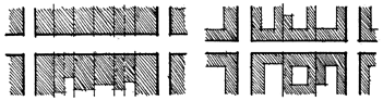
relationship between building and street, the "rule" of Hispanic form
existing in 1821 was no setback and minimal openings. The range for
possible changes toward nineteenth-century Anglo form might look
something like this:
In this specific example, a zone of transition between building and street
is created in moves that are increasingly discontinuous with the existing
condition. The first move, a portal, is subtractive–the transition is
created within the form of the building. The second move, a porch, is
additive-space is defined in front of the building by adding new materials. The third move produces a level change, further separating the public territory of the street and the private territory of the building, and the last move adds an open zone of landscape between the porch and the
street. In addition to the spatial characteristics described above, there
are progressive changes in materials and construction (from adobe to
wood frame), and form (from flat roof with parapet wall to pitched
roof). The character of details may also change, in this case from simply
corbelled post-and-beam connections to elaborate millwork decoration.
The range of actual conditions and changes shown above represents
only a part of a longer change when the cultural ideals for a given form
are considered. For the form shown above, the ideal is described in
Ordinance 115 of the Laws of the Indies, which called for portales on
buildings around the square. Additionally, there was an implicit ideal of
elaborate details (evidenced in certain churches of the colonial period,
where doorways and corbels were carved in decoration). However, frontier conditions with respect to available materials, technology, skilled craftsmanship, and time meant that the ideal was not fully achieved for most forms, which can be thought of as a starting point somewhere
short of the ideal. The degree to which ideals were achieved or altered at
different levels are of interest in this study.
The analysis that follows is based on three forms of information:
narrative histories, photographic images, and graphic abstractions (maps
and diagrams) of the towns of Las Vegas, Socorro, Albuquerque, and
Santa Fe, New Mexico; and Tucson, Arizona. As with any historical
study, it is limited by available information. Narratives are often difficult
to interpret without knowing the author's predisposition and intended
audience. Added to this is the fact that documentation of Hispanic
towns in the early part of the 1800s is almost exclusively by Anglos–a
description by a Mexican might have taken an entirely different tone.
Similarly, drawings are subject not only to the representational skills of
the observer, but also to his or her attitude about the subject. The earliest
photographs were not taken until the final third of the nineteenth century, after some transformations had already occurred. It is possible from some of these photographs, however, to gain at least a generalized picture of the physical environment that existed prior to Anglo arrival.
The most detailed documentation comes from the Sanborn Fire Insurance Company's maps, the earliest of which dates from 1883. These maps contain information about the use, size (footprint), number of
stories, and type of construction. They were revised approximately every
three years, and thus provide valuable data about remodeling, demolition, and new construction. The maps of transformations (see figs. 28-32) are derived from Sanborn maps for each of the five towns. For these towns, I have summarized changes within the framework of scale levels
and transformations. This section is not intended to present "capsule"
histories of the towns, but rather to emphasize certain periods and
events particular to place, at the same time collectively building up a
more general urban history of the region. Following this section I conclude with a comparative analysis and summary thoughts about the importance of physical continuity in preserving a sense of regional history.
URBAN HISTORIES
Santa Fe
One of the first descriptions of Santa Fe after 1821 is from Josiah
Gregg's Commerce of the Prairies, a book written after Gregg had made
several trading expeditions to New Mexico and Texas from the Midwest.
The following quotation describes Santa Fe as he saw it in 1831 and
provides us not only with his reaction to the town, but also with a
detailed description of the form and construction of the houses.
A few miles before reaching the city, the road again emerges
into an open plain. Ascending a table ridge, we spied an extended
valley to the northwest, occasional groups of trees, skirted with
verdant corn and wheat fields, with here and there a square block-like protuberance reared in the midst. A little further, just ahead of us to the north, irregular clusters of the same opened to our view. "Oh, we are approaching the suburbs" thought I, on perceiving
the cornfields, and what I supposed to be brick-kilns scattered in
every direction. These and other observations of the same nature
becoming audible, a friend at my elbow said, "It is true those are
heaps of unburnt bricks, nevertheless they are houses-this is the
city of Santa Fe. (Gregg 1844:54)
In architecture, the people do not seem to have arrived at any
great perfection, but rather have conformed themselves to the
clumsy style which prevailed among the aborigines, than to waste
their time in studying modem masonry and the use of lime. The
materials generally used for building are of the crudest possible
description; consisting of unburnt, sun-dried bricks, cemented
together with a species of mortar made of simple clay and sand.
These bricks are called adobes and every edifice, from the church
to the palacio is constructed of the same stuff. In fact, I should
remark that although all Southern Mexico is celebrated for the
magnificence and wealth of its churches, New Mexico deserves
equal fame for poverty-stricken and shabby-looking houses of public worship.
The general plan of Mexican dwellings is nearly the same
everywhere. Whether from motives of pride, or fear of savages, the
wealthier classes have adopted the style of Moorish castles; so that
all the larger buildings have the appearance of so many diminutive
fortifications, than of private family residences. Let me add, however, that whatever the roughness of the exterior, they are extremely comfortable inside. A tier of rooms on each side of a
square, comprising as many as the convenience of the occupant
may require, encompass an open patio or court, with but one
door opening into the street–a huge gate, called la puerta del
zaguan, usually large enough to admit the family coach. The back
tier is generally occupied with the cocina, dispensa, granero
(kitchen, provision store and granary), and other offices of the
same kind. Most of the apartments, except the winter rooms, open
into the patio; but the latter are most frequently entered through
the sala or hall, which, added to the thickness of their walls and
roofs, renders them delightfully warm during the cold season,
while they are perfectly cool and agreeable in summer. In fact,
henuned in as these apartments are with nearly three feet of earth,
the), may be said to possess all the pleasant properties of ceflars,
with a freer circulation of air, and nothing of the dampness which
is apt to pervade those subterranean regions.
The roofs of those houses are all flat azoteas or terraces, being
formed of a layer of earth two or three feet in thickness, supported
by stout joists or horizontal rafters. The roofs, when well-packed,
turn the rain off with remarkable effect, and render the houses
nearly fire-proof. The azotea also forms a pleasant promenade, the
surrounding wafls rising usually so high as to serve for a balustrade, as also a breast-work, behind which, in times of trouble, the combatants take their station, and defend the premises.
The floors are all constructed of beaten earth "slicked over"
with soft mortar, and generally covered with a coarse carpet of
domestic manufacture. A plank floor would be a curiosity in New
Mexico, nor have I met with one even in Chihuahua, although the
best houses in that city are floored with brick or squares of hewn
stone. The interior of each apartment is roughly plastered over
with a clay mortar unmixed with lime, by females who supply the
place of trowels with their hands. It is then whitewashed with
calcined yeso or gypsum, a deleterious stuff, that is always sure to
engraft its affections on the clothing of those who come in contact
with it. To obviate this, the parlors and family rooms are usually
lined with wall-paper or calico, to the height of five or six feet. The
front of the house is commonly plastered in the same manner,
although not always whitewashed. In the suburbs of the towns,
particularly in the villages and ranchos, a fantastic custom prevails
of painting only a portion of the fronts of the houses, in the shape
of stripes, which imparts to the landscape a very striking and picturesque experience.
Wood buildings of any kind or shape are utterly unknown in
the north of Mexico, with the exception of the occasional picket-hut in some of the ranchos and mining-places. It will readily be perceived, then, what a flat and uncouth appearance the towns of
New Mexico present, with houses that look more like so many
collections of brick kilns prepared for burning than human abodes.
(Gregg 1844:107-9)
From his description of "the Mexican house," we can ascertain that
Gregg was the guest of some of the wealthier families. Other visitors to
the area described the "common" house as consisting of one room, the
doorway covered with fabric or hides, and having either no windows at
all or only a few small openings. The interior walls of these houses were
also whitewashed and covered to five feet with calico or paper; the floors
were hard-packed earth; and a banco ran around all sides of the room
(Bloom 1959:177-78). Others commented on the comfort of the adobe
houses, and the difference between exterior appearance and interior
quality: a North American soldier wrote in his diary: "I was surprised
upon entering them. . . . I found everything very neat and clean and
fumished very tasty" and, "Nothing can exceed the comfort and convenience of the interior. The thick walls make them cool in the summer and warm in winter" (Bloom 1959:177).
Santa Fe was the first permanent Spanish settlement in the Southwest, founded in 1609 by the governor of the northern province, Pedro de Peralta, in accordance with the Laws of the Indies. If a plan of the new town was sent to the Viceroy as required by the ordinances, it has
since been lost; the earliest map, drawn by Jose de Urrutia in 1776,
shows the structure and extent of the built form at that time (fig. 3). The
structure in general follows that given by the Laws of the Indies, and
several of the specific ordinances were carried out to the letter, including
the siting on a plain between river and mountains, and the location of
the church on a site removed from the plaza, yet stiff given importance
by its termination of the axis of a, main street leading away from the
plaza. The orientation, original rectangular shape of the plaza, and location of the Govemor's Palace also correspond to the ordinances.
Comparison with the Gilmer map of 1846 (fig. 4) reveals more about
the structure of the embryo town, showing patterns of growth at the
building, district, and city levels. Buildings that began as a row of rooms
along a street have been extended to enclose courtyards; in a similar
way, the central district around the plaza has been infiued (including
one whole block that appears to have originally been intended to be part
of the plaza), giving definition to the open space; and the city has been
extended by the addition of a "public grounds" and associated military
buildings to the north of the old Governor's Palace.
In the years before this map was drawn, some important changes in
Santa Fe's public spaces were made by the Mexican governor Martinez
de Lejanza. These were described in a 1912 interview with the son of the
subsequent governor, Albino Pérez. Insofar as they represent efforts toward achieving cultural ideals of Mexican city form of that time, they warrant consideration.
[Governor Martinez de Lejanza's] first steps were taken in making improvements within the plaza square where there was not a single tree or any vegetation, and in the same condition were the
streets running out of the square in different directions. He commanded that uncultivated trees be brought from the mountains east of Santa Fe, and caused them to be planted symmetrically
around the plaza and in the streets.
The butchers who killed sheep placed the meat on perches
which they placed under the cottonwoods planted in front of the
Old Palace; on the west side, under the spacious porch of the
Palace, the bakers were installed together with the fruit vendors
and others who sold divers kinds of food for the people who depended on the market for their supply, for at that time there was no public building for the sale of such articles. Besides that, there
were several women who cooked dinners which were served to those who wished to take them there, and under the shadow of the cottonwoods the tables were placed for the boarders. (Read
1927:92-95)
This description further provides a good image of the activities that
took place in the plaza during this period. The use of portales to shelter
vendors is consistent with the Laws of the Indies: Ordinance 115 calls
for the plaza and main streets going out from it to have portales "for the
convenience of the vendors who generally gather there" (Read 1927: 95). As Pérez indicates in his comment about the lack of a public market
building, such facilities were often present in Mexican towns by the mid
nineteenth century, as market functions outgrew the plaza and were
deemed to conflict with the importance ascribed to the governmental
and religious buildings located there. Infill of "empty" plazas was wide-spread during the nineteenth century throughout Latin America; landscaped parklike spaces were a European import that persists to the present day in most plazas. Santa Fe was not alone in this transformation;
plazas in Tucson, Albuquerque, and Las Vegas all were landscaped during the period covered by this study. In terms of continuity, it's a fair leap down the range: from an open volume defined by building edges to one filled in with a mass of foliage, under which run formalized, symmetrical
paths. It corresponds to a transformation in culture: from the plaza de
armas needed for mobilizing defense on the frontier, to a parque central
that exemplified progressive civilization in the courteous intersections
of its tree-lined paths.
In the same account, Pérez described the construction of an alameda
to the northwest of town.
In addition, General Martinez ordered that a plot of ground be
selected on the Northwest side of the city for the plantation of an
Alameda or Park of Recreation, which land was chosen by himself
near the ancient country chapel of the Virgin of the Rosary, south
of the same, wherein cottonwood trees and shrubs were planted
[description of how the Alameda was irrigated with an acequia fed
by the acequia madre]. At the same time the work was being done
in the acequia, the work also proceeded on the Alameda, leveling
the land and forming the streets which started from the center of
the square in different directions, an adobe wall being constructed
all around the square; seats were placed along the streets, and in
the center of the circle reserved for a cock pit. . . . On the west
side, outside the enclosure of the Alameda, an adobe house was
built to serve as residence for the man who was going to care for
the Alameda. . . . After two or three years of being planted, [the
trees'] ramada served as shade during the hot summer days. (Read
1927:95)
It is interesting to compare this account of Santa Fe's alameda with the
one described by Lt. Pike in Chihuahua, which follows the actual definition of the term. Chihuahua's alameda was similarly situated on the outskirts of the city, but along the river; a linear element that functioned as a promenade. Santa Fe's, on the other hand, was conceived as a centratized form, replicating the plaza as an enclosed space with streets running outward from the center. It is visible at the edge of Gilmer's 1846 map (fig. 4).
Pérez's narrative depicts a rather pleasant setting and activities, and it
is worthwhile to consider the contrast between this Hispanic description and those of Anglo observers who saw nothing but disarray and poverty. One might conclude that the idea of a plaza, as an organizing
element, with its associated streets, portales, civil and religious buildings,
etc., was the important thing–in Pérezs mind a clear order existed in
the built form of Santa Fe, embedded in Hispanic culture but invisible to the Anglos.8
In an 1847 article in the Santa Fe Republican, hopes expressed for the
city's growth also reveal prejudicial Anglo attitudes toward the Hispanic
environment.
The merchants have fitted up large and convenient rooms in
place of the small and crowded ones, and the doors, windows and
other marks of improvement that strike the eye everywhere indicates [sic] a most rapid improvement–The ruins of old houses which were scattered all over the town, have given place to new and better built ones, and as fast as workmen and materials can be
procured, new buildings are going up. Not a street in the place
presents the appearance it did, this time one year ago, and if things
continue in one more year, the whole appearance of the city will
be changed. (Bloom 1959:73)
In the Spanish and Mexican periods, commercial activity was conducted from the front rooms of houses around the plaza and on the main roads leading into town. Within ten years of United States occupation, commercial activity in Santa Fe had grown to require the following
buildings: one hotel, one printing office, twenty-five stores, three shoemakers, one apothecary, one bakery, and two blacksmiths (Crouch, Garr, and Mundigo 1983:86). This change in the number of public buildings parallels a process of change from a subsistence to a market economy, a
transformation that was occurring in Mexican culture as well as Anglo.
In the case of Santa Fe, economic change was fueled on the supply side
via the Santa Fe Trail, by goods previously unavailable to the New Mexican population, and by the demand created by U.S. military personnel stationed in the region after 1846.
Increased market activity resulted in transformations of form and
structure during this early period of the Anglo American frontier. Comparison of the bird's eye view of 1882 (fig. 5) with the Gilmer map reveals a large amount of infill in the area surrounding the plaza. At the building level, some buildings or parts of buildings have been demolished to be replaced by new buildings. As the 1885 photo (fig. 7) shows, some of
these were two-story structures. A common transformation was infill of
courtyards and subdivision of buildings perpendicular to the street to
maximize the number of buildings with street frontage near the plaza.
Porches were added on to some buildings, in some instances with imported millwork details. The sequence of photographs of San Francisco Street (figs. 6 and 7) shows the character of subsequent transformations.
At the district level, a new district that breaks completely with the
Hispanic structure and form has been created by infilling the former
"public grounds." The military barracks surrounding the former public
grounds have been demolished, and the area has been subdivided into
individual lots. The new district expresses the Anglo American cultural
ideal of the house as a discrete object in the middle of its lot: the house
made defensible by open space (a stranger could be seen crossing it) in
an era when the safety of a civilized town replaced the dangers of the
frontier, where houses were made defensible by impenetrable walls that
enclosed a courtyard.
For other parts of the town less affected by commercial activity, transformations were slower in coming and limited to the smaller scale levels. Photos of two side streets (figs. 8 and 9) in 1885 and 1910 show little change. The view of Burro Alley is taken looking north from San Francisco Street, and in the left foreground are evidences of the commercial
transformations described above: a pitched roof porch complete with rain gutter, and a cast-iron street signpost–minus the signs and a solid foundation. The facades of Burro Alley, however, look as they did prior to the American occupation. By 1910, the buildings along Alto Street
had acquired screen doors, wood stoops, and some pedimented lintel details of the "territorial" style–all transformations at the detail level.
That so much of Santa Fe's Spanish form and structure remains today
is due to a number of events of the last two decades of the nineteenth
century. The most important was undoubtedly the decision by Atchison,
Topeka and Santa Fe Railroad Company to bypass the town, heading
southwest from Las Vegas over the most accessible pass and ending up at
Galisteo, about eight miles south of Santa Fe. There had been some expectation on the part of the town's businessmen that the Denver and Rio Grande would bring a line through from the north and connect Santa Fe with Galisteo and points south, but the D&RG chose not to build
that line, leaving Santa Fe without a railroad connection. The business
leaders and city council, faced with certain economic decline, quickly
raised enough money and made the necessary arrangements to build a
spur from Galisteo to the southwestern edge of the city, three-quarters
of a mile from the plaza (Simmons 1982:214). This indirect link to the
main artery of Anglo cultural transfusion served to buffer Santa Fe from
the kind of wholesale change experienced by the other towns in this
study.
More subtle but in the long run of great importance to the preservation of Santa Fe's Hispanic environment was a shift in attitude: "A psychological change toward the country and its Spanish-Mexican-Indian culture took place in 1884, when the writer Charles Loomis began to
praise the beauty of the Southwest" (Lamar 1966:169). Writing about
Santa Fe around the turn of the century, historian Bainbridge Bunting
says that "anglicization" was embraced by the well-to-do of both Anglo
and Hispanic populations, but that there was a countercurrent of "conservationists," a loosely knit group of artists, historians, anthropologists, "plus a group that lived on remittances from their families in the East" (Bunting 1983:6). The archaeologists Adolph Bandelier and Edgar
Hewett, along with others, promoted conservation of Pueblo and Spanish architecture and carried out a restoration of the Govemor's Palace in 1916. Collectively, their influence on the future direction of planning in Santa Fe was strong-Hewett wrote that between 1912 and 1917, 90
percent of all remodeling and 50 percent of all new houses in the city
were in the "pueblo" style (Bunting 1983:6).
Albuquerque
Based on the report of Albuquerque's 1706 founding made by the
governor to the viceroy, we would imagine the new town much as is
described in the Laws of the Indies model. Governor Cuervo's report
stated that 35 families (252 persons in all) had built their houses and
corrals and settled into the new town; that a church had been built and
the priest's house begun; and that work had commenced on the casas
reales on the plaza. He reported also that acequias were functioning and
that the town was "well-arranged," fully complying with the Laws of
the Indies (Simmons 1982:87).
The reality, however, was that Cuervo was only temporarily serving
as governor and apparently was desirous of being confirmed permanently in the position. Hence, the report was inflated: later testimony about Cuervo's administration revealed that the original number of
settlers was closer to 100 and that they had simply reoccupied existing
ranchos stretched along the Rio Grande for two and a half miles. These
ranchos had been abandoned during the 1680 Pueblo Revolt and only
gradually reinhabited during the 1700s. The small villages of Atrisco, on
the west side of the Rio Grande at Albuquerque; Alameda, a Tiwa settlement about six miles to the north; and Isleta, twelve miles to the south preceded the founding of Albuquerque (Simmons 1982:89).
Albuquerque's dispersed settlement pattern persisted throughout
most of the eighteenth century. Reports from a Spanish general in 1726
and priests in 1754 and 1776 describe the "town" as strung out along
the river. Father Manuel Trigo in 1754 wrote tongue in cheek of the
"site" of the viua of Albuquerque, "for the settlers, who inhabit it on
Sundays do not live there. They must stay on their farms to keep watch
over their cornfields" (Simmons 1982:91). What Marc Simmons refers
to as a "lack of genuine urbanism" in his history of Albuquerque, has
also been described as a settlement pattern combining "urban life and
rural work" (Jones 1979:241). Whether settlers commuted on a daily or
weekly basis between field and town is a matter of some disagreement
(Jones 1979:241; Simmons 1982:91); the reality probably allows for
some variation. In fact, this practice is both widespread and long-lived:
so-called "empty villages," inhabited only for market and religious functions, have been documented among the Maya in Guatemala (Hill and Monaghan 1987), and in some communities in northern Mexico, families still travel to outlying fields and pastures during the week, returning
to their houses in the village on weekends (author's experience in Banamichi, Sonora, 1972). Simmons writes of Albuquerque that "after a church was up and fanctioning, the citizenry evidently erected second homes or 'Sunday residences' on or near today's Old Town Plaza. . . .
Only gradually in later years did a body of permanent residents take root
around an emerging plaza" (Simmons 1982:91).
Most historians of the Spanish borderlands agree with Trigo's assessment and attribute this departure from the Iberian urban village described by the Laws of the Indies simply to the need to protect distant fields from raiding Indians. From the time of its founding in 1706 until
well into the Anglo territorial period, Albuquerque and other middle
Rio Grande settlements were threatened by Apache raids. Between
about 1750 and 1780 attacks by northern Comanche tribes put additional stress on the dispersed settlements. In 1777 the newly appointed governor of the province received instructions from the commandante general of the Provincias Internas to collect the scattered ranchos along the Rio Grande into "pueblos in good order, walled, close to fields of
labor, and filled with fifty families each," and Governor de Anza consequently "reduced the viua of Albuquerque to a regular form" in 1779, according to a report by Fray Augustin de Morfi (Reps 1979:48). There are no records of what this actually entailed; however, Albuquerque did
experience some growth in population during this period, as ranchers
moved in from outlying farms. The plaza in front of the church was
designated a plaza de armas for collecting and parading troops called up
to pursue Indian raiders. Also during this period some more compact
villages were founded. Plazas were towns of a few to a dozen families,
the houses contiguous and facing inward, enclosing a common plaza.
This form of settlement continued to be used in the region into the
Mexican period. Once Governor de Anza had eliminated the Comanche
threat with an aggressive campaign of pursuit into what is now Colorado, the pressure for concentrated settlement lessened, and new settlements were created in the middle valley. The villages of Ranchos de
Albuquerque, Los Barrelas, Los Griegos, and Los Duranes are examples
of this growth. The location of these outlying settlements survived into
the twentieth century as barrios in the city of Albuquerque.
Another important factor in the creation of these new settlements
was the increasing shortage of arable land around Albuquerque. The
Spanish practice of partible inheritance, combined with the need for
frontage on an acequia led eventually to a pattern of long, narrow plots
running perpendicular to the ditches, plots that in some cases after generations of division and subdivision were only a few yards wide (Johnson 1980: 10). In 1753 a group of Albuquerque citizens petitioned the governor for a grant of land on the Rio Puerco (to the east), citing a lack of
land and means of earning a living as justification for their request.
Their petition was granted the following year, along with another grant
to some "peaceable Indians" at Camuc, at the foot of the Sandia Mountains (Simmons 1982:107).
This return to a more dispersed pattern of settlement (although it
differed from the earlier patterns in the important respect that the new
settlements were more collective in nature) no doubt detracted from the
growth of Albuquerque's population; however, the importance of the
villa as a center of civil, religious, and military functions increased, since
none of the new villages had its own cabildo (town council). The petitions for the Puerco and Carnue grants, for example, were heard in the casas reales on the plaza of Albuquerque. As pressure for irrigable land around Albuquerque increased in the second half of the century, disputes over ownership and boundaries became more frequent, and the activities in the casas reales drew many people to the plaza.
The dominant presence on the plaza was the church of San Felipe
Neri. The original church was constructed on the west side of the square
beginning shortly after the villa's founding. A walled camposanto was
added in front in the 1750s. Lack of maintenance of the adobe structure
led to its collapse in the winter of 1792-93, and the present building on
the north side of the plaza was begun the following spring (fig. 10).
Albuquerque's emerging role as a center for economic activity in the
middle valley also contributed to its population growth. Beginning in
1753 Albuquerque was designated as the collecting point for the annual
trading train south to Chihuahua and Ciudad Mexico that left in the fall
(Simmons 1982:116). Goods were bought in from outlying ranchos
and other towns and loaded onto wagons for the trip south. The same
concentration of economic and social activity occurred when the wagon
train arrived back from Chihuahua.
A census taken in 1822, just after independence, included settlements
for three leagues along the Rio Grande and recorded a population of
2,302 living in 416 houses. Its living of occupations provides some
insight into Albuquerque's economic structure at the time. There were
297 farmers, 15 merchants, 13 craftsmen, 121 day laborers, 3 teachers,
and 1 priest. The presence of merchants and craftsmen indicates the beginning of economic diversification, which increased as other Missouri traders followed BeckneWs tracks to Santa Fe and continued southward on the Camino Real. Simmons characterizes this activity as a "minor
rush" and says that the New Mexico market was quickly saturated, causing traders to look southward to Chihuahua and Durango. A few wealthy Albuquerqueans entered into commercial activity, buying merchandise
in St. Louis and Westport and selling it in Chihuahua (Simmons 1982:
132). The activity resulted in few recorded changes in the built environment, although one can imagine that American-made articles appeared in the houses of those who could afford to buy them, and that perhaps some Albuquerque homes were expanded or remodeled to accommodate increased commercial activity.
American military occupation of New Mexico began when Stephen
Keamey's troops marched unopposed into Santa Fe in 1846. After the
Treaty of Guadalupe Hidalgo was signed in 1848 the Albuquerque post
of the U.S. Cavalry was established, adding significantly to the town's
economy: it employed thirteen civilians, rented buildings for offices,
storehouses, and quarters, and bought corn, mutton, flour, beans, hay,
and firewood. In addition, the troops patronized the town's merchants–including the first saloons, which were established in 1850. The first flour mill was built during this period.
The market created by the military post was served in part by Anglo
merchants who settled in Albuquerque in the 1840s and 1850s. The
Anglo population outside of the military "numbered no more than several dozen" in the 185Os. Ten years later there were still only fifty resident Anglos, a dozen of whom were women (Simmons 1982:149). For the most part, these early Anglo settlers were assimilated into the dominant
Hispanic culture. Simmons notes that since most of the arable land was
already under cultivation, American immigrants to Albuquerque "entered into the life of the community as merchants, tradesmen, artisans, and innkeepers."
As providers of goods and services in what was predominantly a
Hispano town, they found it both expedient and desirable to
adapt wholeheartedly to prevailing custom. Many of these men
married native Albuquerqueans and gained thereby important social connections. At no extra trouble, they also acquired what was then termed a "sleeping dictionary," that is, a wife who could teach
them Spanish. Practically all business and social discourse was in
that language. (Simmons 1982:202)
The plaza during this period was described by one soldier as being
two to three acres in size; it extended farther east and south than it does
at present (Reps 1979:48; Simmons 1982:170). By the late 1860s, there
were nine mercantile establishments on and around the plaza. Susan
Magoffin recorded this perfunctory description of one such store on the
plaza in 1846: "The building is very spacious, with wide portals in the
front. Inside is the patio, the store occupying a large room on the street.
This is filled with all kinds of little fixings, dry goods, groceries,
hardware, &c" (Drum 1926:152). The form of the plaza as defined by
its irregular edges (see fig. 30) is no doubt the result of Albuquerque's
ambiguous urban history of partial settlement, abandonment, and resettlement: boundaries once marked by the governor were forgotten, and individuals acted in the absence of strong conununal constraints. For
example, it appears as though the block of buildings on the east side of
the plaza was added, the large courtyard house behind it being the original edge. This appears to be the case because there is a portal establishing the front of the courtyard house, and because the newer buildings depart from the standard width of the older buildings.
In 1854 Albuquerque was designated the county seat, and an adobe
courthouse was built on Main Street north of the plaza, replacing the
casas reales of the Spanish and Mexican periods. Without visual records
we have no way of knowing whether this building followed the existing
Hispanic forms or whether it incorporated forms and details of Anglo
culture. The earliest Sanborn map (1891) shows a cast stone courthouse
to the south of the plaza that was completed in 1886 and is representative of nineteenth-century Anglo American architecture in plan form and siting.
To the west of the plaza were several acres of military warehouses,
most of which were burned during the initial retreat of Union troops in
Civil War fighting in 1862. The yearlong Confederate occupation of
Albuquerque and the middle valley, followed by a severe drought, temporarily stalled economic growth. Abandonment of the army post in 1867 was another blow. Yet the decade of the 1870s was one of growth,
due to an expanding market for mercantile goods throughout the territory. Albuquerqueans took advantage of the opportunity to act as wholesalers to smaller firms.
There is no visual record of Albuquerque's early form and structure.
Maps showing successive stages of growth such as those for Santa Fe do
not exist, detailed written descriptions are few, and the earliest photographs are associated with the arrival of the railroad. Photographs of Old Town taken in 1880 and 1897 (figs. 11 and 12), however, provide us with an image of the adobe buildings and streets of varying widths that existed during the Mexican period.
In the late 1870s, anticipation of the arrival of the railroad fueled a
flurry of speculation. The Atchison, Topeka and Santa Fe Company had
just completed track through Las Vegas and was starting south from the
junction at Galisteo, below Santa Fe. Three prominent Anglo businessmen acted as agents for a new real estate company actually owned by AT&SF, buying farmland and deeding it to the company in return for a
50 percent share of the resale profit once the railroad reached the town
(Simmons 1982:218). The location and orientation of the tracks was
determined by a straight line between where the railroad came around
the Sandia Mountains and the best river crossing about twelve miles
south of town. Albuquerque was situated in a bend of the river, not
quite two miles west of the line drawn by railroad engineers. The depot
was to be located on the road leading to Carnue Canyon.
When the tracks actually reached Albuquerque in April 1880, an all-day celebration was held, during which speeches were given that predicted Albuquerque's rise to a city of major importance and the beginning of a new era. The ceremonies were half in English and half in
Spanish, a balance that was about to be upset. This intention was proclaimed by one speaker at the ceremonies.
Today the new civilization of the East is brought into direct contact with the ancient civilization of New Mexico. Today the bell of the locomotive tolls the death knell of old foggyism, superstitions, and ignorance, and proclaims in clarion notes that henceforth
knowledge, education, advancement and progress shall be the
right of our people. (Simmons 1982:208)
The large numbers of Anglos arriving on the railroad after 1880
brought a very different attitude than had the early immagrants who had
adapted to Hispanic culture. The newcomers generally held disparaging
views of Hispanos and their physical environment. Simmons writes that
"the latest breed of Anglos was impatiently progressive and smugly confident that it was their manifest destiny to build a new community trackside that would be a perfect model of the standard American mid-western or eastern town (Simmons 1982:234).
The New Mexico Town Company hired a civil engineer associated
with AT&SF to lay out the new town. There were to be seventeen streets
running north and south between the tracks and the edge of Old Town
and four on the cast side of the tracks crossed by as many streets running
east and west. What property the Town Company didn't hold was
bought up by other Albuquerqueans, Anglo and Hispanic, for subdivision and resale. The first "prestige suburb" was east of the tracks, raised above the floodplain of the Rio Grande on the first of a series of old river terraces ascending toward the foot of the mountains.
Construction of the new business district along Front Street was well
under way by 1881 (fig. 13), the first frame buildings erected quickly
with lumber brought in on the railroad. Later buildings along Railroad
and Gold avenues were constructed with a variety of materials, including
cut and cast stone, brick, and cast iron as well as adobe. The new buildings also represented a range of imported architectural styles.
A mule-drawn streetcar system was inaugurated in 1880, providing a
physical-connection between the two towns. Despite the attempts to tie
Old and New Albuquerque together, competition between them was
inevitable. There were battles over the location of the county courthouse
and the post office, and when two post offices were created as a compromise, there was a battle over the name itself. Although Old Town won the courthouse, New Town gained in social and economic importance
during the 1890s. The 1886 bird's-eye view and the 1898 map of Albuquerque (figs. 14 and 15) show clearly the relationship of the two towns
(the map literally maginalizing Old Town). Visible in the map is the
superposition of the Anglo grid on the Hispanic patterns–the acequias,
long lots, courtyard houses, and clustered character of several barrios
coexist uneasily with a regularized grid of uniform lots and streets.
Socorro
Socorro was originally established as a mission to the Piro Indians in
1626. The settlement was sacked during the Pueblo Revolt, and the Piro
moved south along with the fleeing Spaniards to establish "New Socorro," one of six satellite settlements of El Paso del Norte, after the reconquest in 1693. It was not until after 1816 that the site was resettled by seventy families as a center for their ranching activities. It remained a
small población with only incidental growth, in part because it was across
the Rio Grande from the Camino Real between Santa Fe and Ciudad
Chihuahua and also because it was continually subjected to attack by
Apache and Navajo Indians. The town experienced a surge of growth in
1854 when Fort Craig was established bv the U.S. Cavalry; the silver
mining activity that began there in the mid 1860s was something of a
buffer when the fort was abandoned in 1885. By that time, however, the
railroad connecting Socorro with points north and south had been completed, as had a spur between the mines at Magdalena to the west and the new smelter. This intensification of mining activity led to a period of boom years for the town-the years just after 1890 were peak years
in population (5,000) and economic activity.
There is no information docwnenting the 1816 layout of the settlement, and the shape of the plaza by 1886, the date of the first Sanborn map, is the result of successive encroachment and decay, comparable to the processes that shaped the plazas in Santa Fe and Albuquerque. The
Spanish-period plaza occupied the area to the north of Kittrel Park,
with the Garcia and Baca houses defining the northeast corner of it (fig. 16). (Kittrel Park was established in the early 1880s south of the plaza
in what was at the time open fields.) In his survey of historic Socorro,
John P. Conron describes the "overall arrangement of buildings" as "organic; that is, the square and the rectangular buildings were erected without regard to a grid street pattern. Although structures ringed the plaza, their random placement and emanation from the plaza is medieval in origin" (Conron 1980:13). In fact, there was more pattern than Conron suggests: while the streets did not follow a precise grid, their position was still governed by right-angle relationships (not a medieval
characteristic) based on the cardinal directions, and although building
orientation varied by five to fifteen degrees, it was not random. Further,
position of the streets was part of an overall symmetrical conception of
the plaza, with an emphasis on the streets at the midpoints (instead of
the corners as dictated by the Laws of the Indies).
The linear and courtyard house forms characteristic of the Spanish
and Mexican periods resulted from a process of accretion, where rooms
were added one by one as needed. This growth form in its various stages
is still prevalent in the first Sanborn map of 1886, partly because, as
Conron notes, "traditional adobes continued to be built after new styles
were introduced" (Conron 1980:11).
The Anglos who came to live in Socorro before the railroad was completed were primarily associated with Fort Craig, either men in the cavalry or merchants serving its needs. Supplies arrived by wagon train, and transformations of the physical environment were limited to what
could be transported by that means. What is generally called the "territorial style" throughout the Southwest is the result of these relatively small-scale changes, the addition of classicizing elements to existing adobe buildings (Sobin 1975). Materials that could be brought in by
wagon included milled lumber, glass, paint, and lime plaster. The details
these were employed to make were derived from the Greek Revival style
(even though by midcentury this style had been supplanted by other
"Victorian" styles in the East): brick copings in a rowlock pattern
suggesting dentits, square porch posts on a wood phnth, door and window moldings with pedimented lintels, sidelights to front doors, and architrave moldings. Besides these additions at the detail level, some dimensioned lumber was also available for porch and pitched roof construction, adchtions at the building level.
Finally, during this early period of Anglo influence Conron notes the
appearance of one new "plan type"–a square plan with a central hallway
and rooms arranged symmetrically on either side (Conron 1980:12).
The three-dimensional form of this plan, with its hip roof, porch, and
figure/ground relationship to its lot does indeed belong to the Anglo
town. There is, however, a precedent for this plan form in Hispanic
culture. The hallway is called a zaguan, and in its original form was
often open at either end, allowing passage of carts or carriages. It is
interesting that the Anglo version of this plan, which continued to be
built as a house form beyond the turn of the century, is now associated
with Hispanic culture since many of these older central neighborhoods
have become Hispanic barrios. The square plan and hip roof are antithetical to the traditional growth form described above; in general these houses do not accommodate growth gracefully.
After 1880 the town grew south and southeast toward the railroad
and depot (fig. 17). The intervening land was platted in a regular grid
pattern, numbered streets running north-south and named streets east-west. The business district expanded along Manzanares Street away from the plaza. A block of buildings on the south side of the plaza destroyed by fire in 1886 was never completely rebuilt, as most of the businesses
relocated on Manzanares Street (Conron 1980:45). New residential districts were added to the city, laid out on the Anglo block patterns of narrow deep lots backing on an alley with houses centered in the lots. The houses were constructed of frame or brick in various revival styles
imported from the East.
Socorro's economic boom was stopped short in the 1890s by two
unrelated events. Silver was demonetized about 1893, resulting in the
closing of most of the mines nearby, and the smelter closed in 1895. In
the middle of the decade, a severe flood from the mountains to the west
destroyed much of the southeastern part of the town near the depot;
many of those who lost property and buildings chose to relocate elsewhere, and the town experienced a decline in population until after the turn of the century.
Las Vegas
In 1821 Luis María Cabeza de Baca petitioned the Diputación General
in Durango, Mexico (capital of the Provincias Internas), for 431,653.65
acres in the area known as Vegas Grandes, land which was granted to
him in 1823. De Baca, however, was subsequently driven off the land by
Indians, and resettlement did not occur until 1835, when a request for
the same land by twenty-nine families from San Miguel del Bado, in
which jurisdiction the Vegas grant lay, was granted with some conditions attached. One was that any newcomers to the settlement would be granted the same privileges as the original twenty-nine families; another stated that the settlers should provide lots for residences and construct a
wall surrounding the town. The grant "set aside 125 varas for gardens,
25 varas for a road to the watering place, and 75 varas on the south for
more gardens. The gardens and roads were to be placed opposite the
square plaza, and across the square a ditch was provided for watering
the land" (Laumbach 1933:247).
Like Socorro, Las Vegas' early settlement history is poorly documented, and there are few written descriptions of the town to suggest its character. The wording of Vera Laumbach's article, from which the above quotation is taken, suggests that the author was not familiar with the Laws of the Indies, or perhaps that the records she worked from
were a poor translation of the original. The "gardens" were probably the
suertes granted to each settler for subsistence farming. There is also little
in the description that suggests the plaza form of the town as it appears
in the 1883 Sanborn map.
Las Vegas' location on the eastern slope of the Rockies made it one
of the first stops eastward on the Santa Fe Trail, thus ensuring a certain
amount of economic activity in the early years. Susan Magoffin and her
husband passed through Las Vegas in 1847 on their way to Santa Fe;
her diary mostly describes the people she saw and the meal served her
party by a local family, but she did note the adobe houses built "compactly about the plaza." They had few or no windows on the outside
walls, but the interior courtyards had openings into the rooms (Drum
1926:43). Travelers coming to the town in later years encountered streets
such as the one shown in fig. 18, where buildings combined conunercial
and residential fiunctions.
Prior to 1879, only one building in the town was not built of adobe;
that was the stone courthouse. Don José Albino Baca built a notable
house in 1855, described as the first house in New Mexico to have a second floor, and as being quite large, with a patio, porches, and balconies
(Laumbach 1933:251). Single-story buildings were not necessarily a condition of the frontier; a nineteenth-century photo of Chihuahua shows
almost all of the buildings surrounding the plaza are of two stories.
An 1846 account described a large open space in the middle of Las
Vegas: streets running in the cardinal directions, about one hundred
adobe houses with parapet walls and "spouts," and a ditch supplying
water for the town (Laumbach 1933:250). Here, as in the comparable
descriptions of Santa Fe, Anglo perception throws a different light on
Hispanic form. Anglos tended to view the plaza as empty, a void or
negative volume "in the middle of' the positive volumes of the buildings. In the Laws of the Indies prescription, the plaza is a much more
positive element; in the figure-ground relationship of buildings and
streets, it is "figure" in its social and spatial importance.
By 1895 the character of the plaza had changed completely (figs. 19
and 20). Brick and stone buildings, several of two stories, had replaced
the adobe buildings around the square, now landscaped in the pattern
of nineteenth-century Anglo American parks. The view in the latter
photograph is looking southeast toward the new town growing up next
to the railroad, and the old commercial district now extends to the Gaffinas River. Between the river and the new commercial district along
Grand and Railroad avenues a gridded residential district complete with
parks had been laid out (fig. 21). The bird's eye view depicts two towns, one Hispanic, one Anglo; analogous to Albuquerque's and Socorro's
situations after the railroad shifted the center of commercial activity.
Street names changed from Hispanic (Gonzales, Lopez) to the Anglo
numbered and named (Lincoln, Douglas, Jackson) system. Unlike Santa
Fe and Albuquerque's Old Town, however, which retained their Hispanic
character after the railroad shifted the focus of new development away
from their plazas, the plaza of Las Vegas was transformed through demolition and replacement to reflect the growing influence of Anglo culture,
and the "old town" is a mix of flat-roofed adobes and pitched-roof frame
houses.
Tucson
The Santa Cruz Valley was originally settled by Spaniards as part of a
system of missiones and visitas under Padre Kino in the early 1700s. In
1744 and 1747 the Spanish king approved advancement of the military
frontier to the Gila River in response to the threat of French expansion
westward from the Gulf of Mexico, and presidios were established in the
Alta Pimerfa. The presidio at Tubac was one of these, situated some
thirty miles south of the present-day site of Tucson. It had a combined
military and civilian population of about 500 in the 1760s. In 1772
instructions were received from the viceroy to relocate the presidio to
Tucson; it is a reflection of the scarcity of funds and personnel that this
was not accomplished until 1776, and further, that the presidio walls
were not completed until 1782. The presidio was approximately three
hundred years on a side, bounded by twelve-foot-high adobe walls three
feet thick at the base. it had a single gate centered on the west side,
around which the first civilian settlement grew up. The interior of the
presidio was split by a row of buildings into two plazas, with military
stores and quarters built along the outer walls. This pattern was maintained after the wafls came down. In 1791, in an effort to induce further
settlement of the area, the governor of the Provincias Internas set aside
four square leagues around each presidio for civilian settlement (Mattison 1946:281). In fact, this had tittle impact outside of the area immediately around the presidio; like the Rio Grande settlements, the outlying Santa Cruz and San Pedro ranches were subject to frequent attacks by Apache Indians, and there was thus little incentive to settle beyond
the safety of the presidio.
In 1821, Tucson had a population of about 1,100 persons, approximately 500 of whom were Spaniards (Sonnichsen 1982:26). They occupied an area of less than two square miles and were engaged primarily in subsistence agriculture and stock raising. In his narrative history of Tucson, C. L. Sonnichsen describes the town in the following way:
At the end of the Spanish period, just before the revolution of
1821, Tucson was a moderately prosperous village in which Spaniards and Indians lived side by side, but the native population was slowly giving way to Hispanics and mixed-bloods. Retired soldiers were occupying fields which once belonged to the Papagos, though
they were not allowed to take possession of the lands controlled
by the mission. Other Spaniards had come up from the south in
response to the settlement law of 1791. . . . There was trouble
between mission Indians and settlers, giving a preview of problems that were to plague the community for many years to come.
(Sonnichsen 1982:27)
During the three decades of Mexican administration, Tucson experienced a general decline–the economy was disrupted by Apache raids,
the mission was weakened by secularization in 1828, and the Indian
population was reduced by disease and a declining birthrate.
The first Americans who came to Tucson during this period were
trappers looking for beaver along the Gila and Santa Cruz rivers in the
1820s. The "Mexican War" in 1846 brought U.S. soldiers to the area,
and when the Gadsden Purchase was finalized in 1854 U.S. troops took
charge of the garrison, bringing with them Anglo settlers who could
make a living serving the military's needs.
Sonnichsen describes the period from the mid 1850s through the
American Civil War as "the great transition" in Tucson's history: a transition related to developing conununication and transportation linkages
to the rest of the United States. The first mail routes became dependable
at the end of the 1850s, the regular arrival and departure of stagecoaches
(at 1:30 P.m. on Tuesdays and Fridays for westbound mail and passengers, and at 3:00 A.M. on Wednesdays and Saturdays for eastbound coaches) imparted a new rhythm to the town's life, where contact with the outside world had been limited to infrequent and intermittent military and government-controlled commercial expeditions (Sonnichsen 1982:43).
Stagecoaches were followed by wagon trains as the number of California immigrants choosing to take the southern route through Tucson rose. This was a period of economic growth for the town; the mines in the region became active again, and there was an increase in the number of military and Indian Agency personnel whose needs generated a corresponding increase in trade. The population doubled between 1850 and
1860–the census of the latter year counted 623. By 1858 there were
three general stores, two butcher shops, and two blacksmiths; 1859 saw
the first saloons, and a gristmill on the Santa Cruz; and by 1869 there
was even a brewery and beer garden established by a German immigrant
(Sonnichsen 1982:59).
The business center of Tucson was Calle de Correo, renamed Pearl
Street in the Anglo Territorial period. The original name indicates the
location of the post office; opposite that was the Buckley House complex, which provided accommodations for travelers and horses, as well as storage for merchandise prior to sale. Contiguous with the Buckley House complex was Pacheco's blacksmith shop and residence. The courtyard complex occupied on one side by the post office contained a store
on the side fronting Calle Real, later Main Street (Sonnichsen 1982:43).
The irregular pattern of this settlement derives in part from Tucson's
origin as a presidio, which occupied the approximate square containing
the Plaza Militar and Plaza de las Armas in Fergusson's 1862 map (fig.22). The civilian community established itself just outside the main gate, within a bend in the acequia serving the presidio. This growth was not
governed by the Laws of the Indies; lacking a plaza as a generator of
form, buildings grew along established routes of travel between the presidio, the river, and the mission. The initial southerly offset (with respect
to the gate) began a pattern of development that shifted southward
around the edge of the old presidio, between its plaza and the Plaza de
la Mesilla. Analysis of the 1883 Sanborn map shows the greatest density
centered around Pennington and Congress and around Main and Meyer
streets.
The Sanborn map of 1883 also shows that the initial business area
west of the presidio gate underwent a cultural "replacement" process as
well as a physical one: the uses indicated on the Sanborn map are "Chinese Laundry," "Chinese Opium Den," and "Chinese Grocery." There had been Chinese in Tucson since the 1860s; when the railroad was completed in 1880, a group settled in this part of town and had developed more than one hundred acres of truck gardens along the Santa Cruz
floodplain by 1884. Pacheco's blacksmith shop was altered by the addition of a new row of rooms behind the first, to accommodate the "lodging house" for Park Brewery, part of the new "entertainment district" west of the acequia.
Tucson was incorporated as a town in 1874, occupying two complete
sections; streets and blocks were laid out parallel to the section lines,
and the street numbers began on the eastern section line–rather than
at the center of town–an indication of the power of the survey grid as
a tool to rationalize the landscape.
The 1870s saw the first public school, and as a consequence, a first
small influx of unmarried Anglo women. Up until this time Anglo merchants often married Hispanic women, thereby assuring cultural assimilation, and in the case of those who married into wealthy families, access to the important social and economic network. The availability of Anglo women in the community marked the beginning of an important cultural shift. Sonnichsen notes that intermarriage became less frequent
throughout the 1870s and 1880s and that newspaper accounts of social
events contained fewer and fewer Hispanic names (Sonnichsen 1982:
88). Although a cause-and-effect relationship would be difficult to document, one can speculate that these Anglo women began to transform
their environment at the smaller scale levels. Certainly their attitudes are
well known through the diaries they kept (Susan Magoffin's diary of her
travels and time in Santa Fe during the 1840s is the best-known example). The adobe house with its dirt floors, whitewashed walls, and dirt roof, which needed constant attention to maintain, seemed primitive to Anglo women used to raised wood floors, glass windows, and painted or papered walls. Beginning with their inunediate environment, the house
interior, transformations occurred at the detail level–rooms were filled
with furniture brought by wagon from the East or Midwest, glass windows and trim were installed in existing openings or new ones, wood boards covered dirt floors–such transformations all fall under the category of addition.
While some prosperous Anglo and Hispanic families continued to
live in and transform their courtyard houses, others constructed new
houses at the earliest opportunity. These houses constituted additions at
the district level, new houses inserted into the existing fabric. The residence of Anglo families in Tucson also created the need for certain related institutions. By the 1870s there were three schools, Methodist and Episcopal churches, a hospital (although this was Catholic), and a public bathhouse. These buildings represent addition and infill at the district level; they appear as isolated structures unrelated in form to their Hispanic environment. Infill at the district level can be observed in the circa
1880 photograph of the Plaza de las Armas (fig. 23), where a church
and landscaped park now occupy the former plaza, and a two-story
house with bay windows has been built on the north side of the plaza.
None of these elements follows the formal rules of Spanish and Mexican
town form, such as continuous street facades (no set-backs), flat roofs,
and open plaza (fig. 24).
Not all of these transformations occurred at the district level: some
buildings were reconfigured or added to as a result of the cultural shift.
An example was the Cosmopolitan Hotel on the comer of Pennington
and Main. An 1874 photograph shows an adobe structure with a heavy
portal, and a subsequent photograph of the same building, rechristened
"The Orndorff," shows that one wing of the building has added to it a
frame second floor and balcony, complete with bracketed cornice (Sonnichsen 1982: 100, 101). A photograph of Meyer Street in the 1880s (fig. 25) shows the addition of several simple porches and at least one
brick parapet coping.
Anticipation of the approaching railroad led to a boom in real estate
values in the late 1870s; when the first train actually arrived on March
20, 1880, "prices on practically everything were rapidly revised downward," causing the financial ruin of several of Tucson's most prosperous
merchants (Sonnichsen 1982:105). Five concerns either sold off stock
to their creditors or went bankrupt in the following four years. This
loss, however, was limited in scope, and in the long run the railroad only
hastened economic and population growth in Tucson.
The new railroad tracks and depot one-half mile from the business
center sprouted a district of warehouses and shops. Congress Street developed as a connection between these two areas, and as Sonnichsen
notes, "it was the first east-west thoroughfare to break the old north-south pattern" (Sonnichsen 1982:107). Unlike Albuquerque and Las
Vegas, where the orientation of the railroad tracks dictated the street
orientation of the "new town," the diagonal path of the railroad through
Tucson simply broke through the grid of blocks and streets, with the
exception of Toole Avenue and the lots fronting the railroad.
An increase in Anglo population relative to Hispanic population resulted in an increase in the pace of environmental change. In 1882, the Arizona Citizen described the "change in building styles" due to replacement of adobe with brick and lumber, observing that "newcomers preferred to freeze in winter and stew in summer rather than live in one of
those 'ugly mud houses.' The idea of stepping through one's front door
into the street was equally repugnant, and in the new districts a front yard
interposed a decent interval between residence and road.... New residents (also) imported the green lawn" (Sonnichsen 1982:107). Wealthy residents built northward on Main Street, their large houses bringing Eastern architectural styles and materials to the desert setting. Reinforcing these directional trends was the location of the university in 1891.
Three businessmen donated forty acres one-half mile northeast of the
railroad depot, creating an impetus for the development of new residential neighborhoods. The first additions to the original two-square-mile townsite after the turn of the century were in this direction.
These initial trends of growth for the Anglo population to the north
and east signaled future patterns: the predominantly Hispanic neighborhoods and the incorporated town of South Tucson remain in the southern sectors of the metropolitan area, while the wealthy Anglo population has leapfrogged to successively higher and higher around in the
foothills of the Tucson, Santa Catalina, and Rincon mountains to the
northwest, north, and northeast, respectively.
One example of infill at the city level is the subdivision of the Old
Military Plaza (fig. 26), now known as the Armory Park neighborhood.
It was laid out in the same pattern of regular lots (50 ft. x 150 ft.) that
was used in the rest of the town and built in the Anglo pattern of "solid"
volumes in the center of open but private territory; again, the antithesis of the Hispanic pattern of building enclosing private open space (courtyard).
As the business district expanded along Main and Meyer streets, it
displaced Mexican American families who, according to Sonnichsen,
were either bought out or forced out; they moved southward, concentrating around the Plaza de la Mesilla, renamed Church Square (fig. 27).
Adjacent to this area on the north in the 1890s was Tucson's "sporting
district," occupying a narrow,, tapering block called "The Wedge." The
Wedge provided Tucson with its first opportunity for demolition at the
district level when it was razed in 1902 in combination with other street-widening work, which constituted overall reconfiguration at that level.
In the last two decades of the century additions were made to the
urban infrastructure. The privately owned Tucson Water Company
began operating in 1882, marking the end of private wells and of a part
of the service sector of the economy: water carriers had sold in the plaza
buckets of water brought from the Santa Cruz for five cents. The city
took control of the water system in 1890, coinciding with work on a
sewer system. An 1881 proposal for streetcars was not implemented
until 1898, when mule-drawn cars went between downtown, the train
depot, and the new university. The mules were replaced by electricity in
1906.
As early as the 1880s Tucson began to see tourists and health-seekers
arriving for the winter months. By the turn of the century this influx
had grown tremendously, facilitated by good passenger rail service and
increasing private ownership of the automobile. Tucson actually experienced a housing shortage in the 1890s as tuberculosis patients camped in tent cities at the edges of town and in the Santa Catalina Mountains (Sonnichsen 1982:141). In spite of this, the city's growth was by no
means assured. "Indian problems" continued into the mid 1880s, when
the last rebel Apaches conducted their campaign of resistance to Anglo
control from mountains in southeastern Arizona. Population in Tucson
actually fell between 1880 and 1890 but then began a rapid rise, reaching 13,000 by 1910 (Sonnichsen 1982:210).
COMPARATIVE ANALYSIS
Having presented something of the history of each of the five settlements with the intention of emphasizing their individual situations and conditions, I will now turn to a more collective analysis based on the hierarchy of levels and processes of transformation outlined at the beginning of the article. Table 1 is a summary of the information in this matrix; these generalizations are drawn from the narrative histories and from examination of photographs and maps.
The following discussion, organized by environmental level, is based
on the idea that at any point in time, for any form in this study, there are
two cultural "models" or ideals, Anglo and Hispanic. These models are
understood to define a "range of intention," the end points of a theoretical continuum on which actual form can occur at any point, depending on local or individual circumstances such as resources available, cultural variables, and even individual idiosyncrasies. As with any model, this
one derives its usefulness from simplifying complex conditions to find
underlying patterns. Throughout the period encompassed by this study
these cultural models were changing in complex ways. Anglo architecture in the eastern and midwestem parts of the country saw a succession of styles, most of which made their way to the frontier. Models of form in Mexico were changing, influenced by developments in Spain and the
U.S. The local and regional chronologies–beginning with Anglos accepting Hispanic forms early in the period then Hispanos rejecting their own forms in preference for Anglo patterns, and in a few cases, back to Anglos adopting Hispanic forms after the turn of the century–add
another layer of complexity. (No attempt has been made here to deal
with relationships between Native American and Hispanic, and later
Anglo, built form.)
Examples will serve to illustrate the concept of a "range of intention"
for various forms. At the building level, if we consider the plan form of
the house, the range of intention could be depicted like this:
From a cellular, additive, enclosing form to a symmetrically ordered, functionally differentiated "whole"
At the same level, the range of intention for the zone of transition between house and street is this:
From a defensive, closed condition of no exchange to an open, multilayered zone between private and public spaces
At the district level for the form of demarcation of private territories
from public ones the range of intention might be expressed this way:
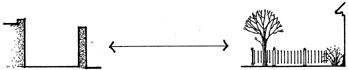
From a wall that creates spatial enclosure and thus visual as well as functional privacy to an "open" demarcation created by landscaping or a fence
As previously mentioned, since the frontier condition affected the realization of both models in this period (albeit less so after 1880), and assuming what was extant in 1821 as a starting point, the actual range of transformation is relative to the range of intention, expressed diagramatically in the following way:

Just as processes of transformation are observable at all levels, this model of cultural "poles" and a range of possible transformation in between is applicable to all scale levels. This underlying assumption has to do with the nature of the hierarchical system of levels: that the "behavior" of form is consistent regardless of size and that size is always relative to the human dimension.
Details
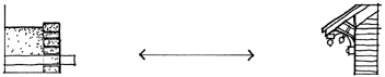
Insofar as this level often represents an elaboration of form at larger
levels, it is more difficult to establish what either of the "models" would
have been because of stylistic variations within relatively short periods
of time. In the case of Hispanic forms at this level in the first half of the
nineteenth century, elaborate detailing around doors and windows in
neo-Baroque styles was common in Mexico. Such detailing-was usually
limited to civic and religious buildings and homes of the wealthy. The
nineteenth-century Anglo American ideal was represented by a succession of revival styles, and there are examples in all of the towns studied of adobe buildings transformed by the addition of Greek Revival, Queen Anne, Itatianate, and Eastlake detailing.
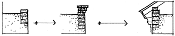
The actual transformation can be characterized as from an almost com-
plete lack of detailing to an intense elaboration of edges–roof edges,
porches, bay windows, balconies, etc. There was, of course, elaboration
of some buildings during the Spanish and Mexican periods, principally
of churches. The corbelled wood capitals of portal posts and supports
used to extend the span of vigas in large rooms is one example.
Transformation of adobe buildings by the addition of materials at the
detail level can be seen in several of the photographs: there are examples
of "territorial" Greek Revival style detailing in Tucson (figs. 23 and 27), Santa Fe (fig. 6), and Las Vegas (fig. 21). In Albuquerque, neo-Gothic details have been added to the adobe church while the adjacent convent
has retained its Greek Revival moldings around the doors and windows (fig. 10)
Buildings
In general, buildings in the Hispanic environment are defensive in
nature–they act as walls to enclose exterior space. The earliest buildings
were simple accretions of rooms of similar size, beginning along the
edge of the street and then extending back to enclose the placita. A
comparison of the two earliest maps of Santa Fe (figs. 3 and 4) reveals this growth process for several buildings. The Anglo American model
was a reversal of this pattern: a freestanding, complete "object" surrounded by open space, centered on its plot of ground. The individual house, the church, and important public buildings such as the library
and courthouse expressed this ideal. If the Anglo American building
grew, it grew awkwardly, by the addition of subordinate forms such as
sheds and lean-tos. J. B. Jackson (1959:31) characterized the two poles
this way: "The basic Anglo American dwelling unit is the house, which
we subdivide into rooms; the basic Spanish American unit is the room,
which is eventually added to."
The accretional growth process is still operative in some of the Hispanic towns in northern New Mexico, as documented by Paul Kutsche and Robert Van Ness in their studies of Cafiones near Abiquiu. As rooms are added to a house, the old ones are often left to weather and subsequently change use from habitable room to storage shed, to stable, to ruin. Combined with this evolution is the tradition of dividing property equally among heirs. In some instances this means that a single house is
in effect transformed into multiple houses through subdivision and addition of new rooms (Kutsche and Van Ness 1981:77). This process was described historically in John Russell Bardett's Personal Narrative (1854: 296): "The homes of Tucson are all of adobe, and the majority are in a
state of ruin. No attention seems to be given to repair; but as soon as a dwelling becomes uninhabitable, it is deserted."
Anglo cultural influence changed the pattern of growth of Hispanic
buildings. Tucson in 1862 had few "complete" courtyard forms, and
transformations of those buildings after that point followed a different
pattern of growth. Analysis of Sanborn maps between 1883 and 1898
(fig. 28) shows that many of the buildings grew by addition of a second row of rooms behind the first. This pattern is also visible in the roof-top photograph from 1900 (see fig. 27), where parapet walls reveal the construction.
Santa Fe, by comparison, had a number of courtyard houses near the
plaza in 1846 (see fig. 4), and they were transformed for commercial use
in a pattern of infill of the placita and subdivision perpendicular to the
street to form long narrow stores. Additionally, courtyard houses were
extended upward with second stories and to the rear with sheds and
storage buildings. This transformation acconunodated the growing
economy by concentrating and expanding space for conunercial activity
and maximizing the number of owners with street frontage. Transformation of courtyard houses that remained in residential use was less radical; analysis of the Sanborn maps (fig. 29) shows demolition of individual rooms and one instance of partial infill of the placita.
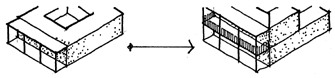
Albuquerque, Socorro, and Las Vegas were similar to Tucson in that
there were fewer complete courtyard forms in the towns at midcentury.
The exact number would be difficult to ascertain because of the lack of
detailed maps prior to 1883, when the first fire insurance maps were
prepared. There could have been courtyard houses that were demolished
and replaced, as occurred later in Santa Fe or, more likely, there were
more partial courtyard forms that were lost in subsequent transformation, as in Tucson (figs. 30-32).
An analysis of the consistency and relatedness of dimensions in the
area around the plaza in Santa Fe reveals the most common dimensions
for forms at each level. These "room" and "house" dimensions in Santa
Fe are repeated fairly consistently in all of the towns except Tucson,
probably because of its origin as an unplanned settlement around the
presidio gate. The typical house dimension, about eighty feet along the
street, was probably a fimction of the size of the original solares granted
to settlers. Although the room dimension is quite consistent in Santa
Fe, it varies more across the towns than the house dimension. Room
size was partly dependent on the structural technology of vigas supporting dirt roofs. As recorded on the Sanborn maps of Albuquerque, for example, rooms along Morris and Short streets south of the plaza are consistently about eighteen feet in the bearing dimension, whereas those
in buildings along Main and Santiago streets to the northwest average
about twenty-five feet. In the absence of a more complete historical
record, one can only speculate as to the reasons–perhaps that the larger
rooms are more recent and employ slightly better materials or more
sophisticated technology, or that the owners were of a higher socioeconomic status.
Some of the adobe commercial buildings on the Sanborn maps are
dimensionally the combination of two "rooms," which suggests the possibility that a center wall was demolished and replaced by columns, and in fact, such columns are drawn in some instances. This sort of transformation acconunodated expanded use while maintaining the overall integrity of the form. In other cases, where the construction is indicated as brick rather than adobe, one can assume that the entire building was replaced.
Spanish and Mexican period buildings were also transformed by the
addition of porches and balconies and pitched roofs, which were often
simply built above the existing dirt roof.
Districts
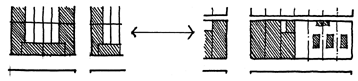
The Hispanic concept of the building-as-wall is repeated at the district level, where a continuous built edge defines the block and street. The original intention of the Laws of the Indies, a square block lined with courtyard houses on all four sides, and enclosing space for gardens
and small livestock, was not fully realized in any of the northern frontier
settlements. This pattern creates a "courtyard" at the next larger scale,
the district. The Anglo American ideal is again a reversal of this pattern:
the residential block is a rationally demarcated surface with buildings as
discrete objects placed in the centers of the subdivisions, a simple multiplication of the lower level form that is no more than the sum of its parts. The commercial block has the same structure. but the building occupies the whole surface. The clearest example of the juxtaposition of
the two patterns is in the infill of the old military grounds northwest of
the plaza in Santa Fe, seen in the Hartmann map of 1886 (fig. 5).

None of the settlements achieved a recognizable repeated block pattern comparable to the Laws of the Indies model during the Spanish or Mexican periods. Most of the blocks in these towns have a directional orientation. Tucson had a few blocks with buildings fronting on all four
streets, specifically near the Plaza de la Mesilla (see fig. 28). In Santa Fe,
the blocks on the south side of San Francisco Street had buildings fronting almost entirely on that street, with a few facing the side streets, until after the turn of the century (see fig. 29). These blocks were originally bounded on the south by an acequia (shown in the Gilmer map, fig. 4), which served the gardens at the back of the houses fronting on San Francisco Street.
In general, blocks in the Hispanic environment tended to be open at
the interior, land behind the house originally being used for subsistence
gardens. Individual parcels were defined by waus and sheds. The Hispanic pattern of transforming the block was through an intensification of the street edge–adding rooms to enclose the placita. The subsequent Anglo pattern in the commercial centers was infiu of the block's interior through subdivision of the land into narrow parcels requiring extension of the building deep into the block.
In the analysis of transformations between 1883 and 1898 in Santa
Fe (see fig. 29), one can observe the commercial pressure on courtyard
houses along San Francisco Street westward from the plaza. It is probably reasonable to assume that this process was similar to what happened
in the area immediately adjacent to the plaza between 1846 and 1883.
The transformations are mostly small in scale; the district being "dismantled" in much the same way it was built up between 1776 and 1846. There is little wholesale demolition, rather subtraction occurred on a piecemeal basis. The overall economic pressure is discernible in the increasing density of built space toward the plaza.
Barrio Analco, visible south of the river in all three maps of Santa Fe,
was the original settlement of the Tlaxcalan servants accompanying the
Oñate Expedition of 1609. The barrio's linear form is ordered by the
acequia, a pattern common to smaller settlements of later periods. The
chapel of San Miguel was built to serve as the mission church. In the
Revolt of 1680, Barrio Analco was the first area sacked by the Pueblo
Indians; it was rebuilt after the reconquest in 1693, and by 1776 it was
inhabited by married soldiers, genizaro servants, and other laborers.
Some of the extant buildings date from before 1776, and the barrio has
retained its cohesive form, making it a recognizable district within the
city (Historic Santa Fe Foundation 1982:42).
Regarding infill of the plaza between 1776 and 1862: a pattern of encroachment began early with the group of buildings in the plaza shown on the 1776 map. By 1862, the block had been defined completely.
Written records attest to problems of encroachment in the plaza area from the 1740s, when Governor Cruzat y Gongora reportedly "bought a house in order to demolish it because it obstructed the entrance to the parish church." In 1756 "Governor Marin del Valle ordered certain citizens to open the streets upon which they had encroached with fences and buildings, especially 'in front of the house of this royal presidio"' (Historic Santa Fe Foundation 1982:17).
It would seem that private appropriation of public territory was common, particularly if we are to interpret frequent Anglo descriptions of irregular streets as in fact describing encroachments on a more well-ordered grid. The Laws of the Indies called for demarcation of the public
areas first (plazas and streets, government and religious buildings), with
private lots defined by their edges. This is quite different from, for example, Islamic traditions of public spaces being "left over" from the physical definition of private territories. This latter pattern was present in sixteenth-century Spain, and may well have been brought to the New
World in the experience of the settlers, frontier conditions making strict enforcement of the Laws of the Indies difficult.
City
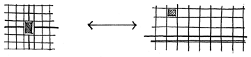
As noted earlier, the Laws of the Indies model of the city was a center-generated, place-making form. The process of founding and laying out the city began with, and emanated from, the plaza (literally, "place"). The planned Anglo American city of the nineteenth century grew out of
a subdivision of the larger grid of the 1785 Land Ordinance survey. In
combination with the railroads, it resulted in a line-generated form emphasizing movement. The Anglo conception of the city did not include the built form, only the surface structure and organization. By contrast, the Laws of the Indies prescribed both form and structure.
While four of the towns in this study have a plaza as their point of
origin and fimctional center, Tucson differs in that it emanated from the
presidio (or more precisely, its entrance) as already mentioned.
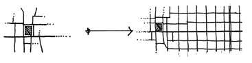
The Spanish townscape was transformed by the Anglo ideal through
addition of districts-i.e., extension-and by creation of "new towns"
some distance from the original plaza. The direction of growth after
1880 was determined largely by the location of the railroad relative to
the business center of town. Thus Socorro's business district extended
toward the railroad tracks, as did the commercial districts of Tucson and
Las Vegas. The orientation of the structure, however, was not always
influenced by the orientation of the tracks through town. In Albuquerque, the fervent efforts of the town's businessmen to attract the railroad is expressed in the alignment of streets in New Town with the tracks, several degrees off the cardinal points. Tucson's street grid ignored the
railroad's orientation, which bisected the original plat on a diagonal.
D. W Meinig characterizes the Old and New Towns of Albuquerque
and Las Vegas by 1900 as "two parts of a whole, Hispano and Anglo,
separate social communities bound into an economic entity" (Meinig
1971:48). In addition to these two towns, Meinig names Socorro and
Tucson as dual towns; I have found some further distinction useful.
While there is some spatial separation in all of the cases (varying from
three-eighths of a mile in Tucson to one and one-half miles in Albuquerque), only in Las Vegas and Albuquerque was there the intention of creating a "new town." In Tucson and Socorro the existing business district simply grew toward the new district of warehouses near the
depot in a process of infiff. The intentional new towns reflected a desire
on the part of Anglos to distance themselves culturally (as well as spatially) from the Hispanic settlement and the culture it represented by beginning anew, building in the image of the eastern half of the country.
The distance between the commercial center and the railroad depot
in Tucson was filled in before the turn of the century, even though there
initial resistance to location of business "so far" from Main
was some in Street. The north and east directions of extension established during
this period have continued; Broadway and Speedway boulevards now
stretch for twelve miles across the desert, connecting the Tucson and
Rincon mountains.
Socorro's depot was a little less than a mile from the plaza. A continuous business district was never achieved because of the decline in mining activity and population beginning in 1895. When the next period of growth began after turn of the century, it rode in on the automobile,
and the new coast-to-coast highway that came through town on California Street kept businesses closer to the original plaza.
The period of growth that followed the establishment of New Town
in Albuquerque took two directions. One was along the road to Carnue,
the extension of Railroad Avenue, which later became Route 66. The
other direction was parallel to the railroad tracks. Albuquerque's early
history as a collection of dispersed settlements was stiff evident in 1900,
where six distinct barrios along the Rio Grande floodplain were visible,
each of which was later enveloped by the growing city.
The exception to the pattern of dual railroad towns in the Southwest
was Santa Fe, where the railroad arrived only as a spur line to a point
southwest of the town. Later maps of the town show that extension
continued along the east-west axis of the river and acequias, not beginning southerly expansion until the middle of this century.
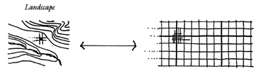
Landscape
The two grids share the intention of rationality inherent in orthogonal relationships. The Spanish grid, like its precedents in the Roman Empire, has the intention of making place in the landscape; the Anglo American grid of the 1785 Land Ordinance sought to rationalize the
surface of the West. The Laws of the Indies town emanated from a place
carefully chosen for its life-sustaining qualities (moderate climate, good
source of water, dry ground, healthful air, etc.). It was not uncommon
for new American towns to be platted starting from the intersection of
two section or township lines.
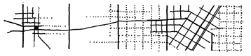
Additions to Hispanic towns were sooner or later "justified" to the
larger American grid. In Tucson this happened when the town was first
incorporated in 1872. The original townsite was two full sections that
included ahnost all of the Hispanic settlement. This unrelenting mile-square grid continues to structure additions to the city within the topographical confines of the Santa Catalina, Tucson, and Rincon mountains. Albuquerque's street pattern, shown on the 1898 map as aligned
primarily with the railroad, was later actually built to conform to the
land survey. It is only in recent years that the growth of Santa Fe has
assumed this structure. Additions to the city through the 1950s continued to be influenced by old agricultural patterns and routes of travel to and from the town.
SUMMARY: "AS WE HAVE BEEN, AND MIGHT BE"
During the period encompassed by this study the character of frontier settlement in the Southwest changed from that of a static outpost of Spanish and Mexican territory to that of an intermediate point through which people and resources moved as the edge of the Anglo American
frontier was pushed further outward from its center. Increased contact through trade and immigration meant more exposure on the frontier to the ideas and material artifacts of its cultural center, which was expressed in transformation of the physical environment.
The transformations revealed in this study can be grouped chonologically into three phases, each of which is defined by a combination of transportation technology and economic activity. The Spanish period in the Southwest from 1598 to 1821, was characterized by extreme isolation–official trading expeditions from Ciudad Mexico and Chihuahua came only once every three years. The two and one-half decades of Mexican administration (1821-48) comprising the first phase of this study
saw some increase in trade and communication, the Santa Fe Trail forming a conduit of economic and cultural exchange between Independence, Missouri, and Ciudad Chihuahua. By midcentury, the beginning
of the second phase, economic ties with the United States dominated
the region. From the signing of the Treaty of Guadalupe Hidalgo in
1848 until completion of the railroad in the 1880s, economic growth in
the region was due to the presence of military and Indian Agency establishments. This was the first strong incentive for urban development–the location of Fort Marcy at Santa Fe, Fort Craig at Socorro, and Fort Lowell at Tucson created concentrated markets for goods and services.
After 1880, during the third phase, railroads affected the magnitude of
this growth; the new transportation technology brought people and
goods to the region at a rate several times that possible by the wagon
trains and permitted the export of resources such as timber, ores, and
livestock to eastern markets.
Urbanization and increasing complexity of the economy translated
into a diversification of building types.9 Initially, residential buildings
sheltered all functions: one or more rooms in the house would be used
for commercial activity or crafts production, in addition to rooms for
storage of foodstuffs. The Buckley House in Tucson, which functioned
as a hotel, restaurant, stables, and warehouse is one example of such a
complex. Specialization of building types and functions mirrored the
process of definition of discrete sectors of the developing economy. For
example, establishment of military posts at Tucson, Albuquerque, and
Santa Fe resulted in the first flour mills and saloons. As stage lines established regular routes, hotels and restaurants were built to accommodate predictable numbers of travelers. Specialization was not limited to the building level, but occurred at the district level as well, where separate
residential, commercial, and warehouse zones gradually became distinguishable during the second and third phases.
This general process of urbanization in the Southwest paralleled
transformation of the Hispanic physical environment. The growth of
towns was fueled primarily by American economic and political expansion, and Hispanic towns on the southwestern frontier were transformed in the image of the cultural center, the eastern half of the United States.10 Consistent with increasing cultural contact between the frontier
and the center, the pace and magnitude of change in the physical environment increased from 1821 until the end of the century, as shown diagrammatically here.
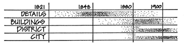
Transformations occurred first at the detail level, later at the building
level, and they were followed in close succession by larger-scale changes
at the district and city levels. At these levels, attempts to change the
Hispanic environment quickly gave way to creating new environments,
resulting in "dual towns" and allowing varying degrees of preservation
of the "old towns."11
This pattern should be read in terms of continuity and discontinuity
of physical form, as well as simply the intensity of change. What is
"white" in the diagram represents continuity of place: the character of
place endures despite the presence of new cultural ideals, which are either
given up in adopting the existing culture, or perhaps, repressed. The
shaded tones represent continuity of culture: the new culture, for whatever reasons, is strong enough that its bearers act to physically alter their environment, to recreate it in their own image. Continuity of culture on an expanding frontier necessarily results in discontinuities of physical
form, whether immigrants inhabit and change existing buildings, districts, and towns, or whether they build new towns in the landscape.
Continuity of culture represents the human impulse to inhabit famil-
iar environments. Continuity of place is passive; the result of continued
acts within an established tradition. In organized colonization of a "new"
land, settlers do not willingly jettison their own culture in preference for
another, particularly if they perceive theirs to be more advanced. Settlers
bring as much "cultural baggage" as resources, distance, and technology
allow. The Laws of the Indies is an example of this: in addition to its
obvious administrative role, the codice was an expedient way of transferring culture over great distances and long lapses in communication.
It is consistent with this idea that the "details" level of the environment was the first condition of discontinuity of place and that there was a general progression from that level through buildings, districts, and cities. In addition to the constraints of available resources in the first
phase, the fact that Anglo settlement in New Mexico was not regulated
(as it was in Texas by the system of empressario grants that enabled
foreigners to settle whole colonies) meant that Anglos either acquired
land and buildings piecemeal directly from Mexicans or occupied what
they determined to be "vacant" land. In any case, they did not settle in
spatially defined enclaves, nor did these first settlers seek to radically
alter their environment. Rather, they were assimilated into the dominant
culture. It was only after the Anglo population had grown sufficiently to
warrant additions to the town (i.e., new buildings and districts) that
such spatial definition of culture began to occur.
Prior to 1880 there were few transformations at higher levels. There
were some new buildings constructed more on the Anglo plan models,
but in the only material readily available, adobe. In Santa Fe the district
around the plaza underwent this sort of change, as new commercial
buildings replaced courtyard houses. In Tucson initial changes in the
commercial district were more discrete: a few Anglo commercial establishments, such as Zekendorff buildings on Congress and Main, were inserted into the existing adobe fabric. Major transformations at the district level, however, awaited completion of the railroads.
There was also an attitude of "disguise" that guided transformation
at the detail and building levels prior to the arrival of the railroads and
continued after 1880 when sufficient resources for larger interventions
were not available. This differed from the simple addition of details
(door and window moldings, "gingerbread" trim, etc.) to adobe buildings, which can be considered as elaboration, or from the addition of practical elements such as brick parapet coping or metal roofing. Instead, it was a literal attempt to hide the Hispanic character of the building through addition of wood or brick veneer or a coating of lime plaster painted to look like stone or brick.
The year 1880 marks an abrupt move toward discontinuity of place
at the larger-scale levels. An increase in the magnitude of immigration,
combined with the sudden availability of building materials from the
Midwest meant that the continuity of Anglo culture became the dominant force of transformation. Inherent in this condition, however, was a reciprocal maintenance of continuity of place: new districts and "new towns" allowed preservation of the old. Albuquerque's New Town meant
that the area around the plaza was not subject to the pressures of commercial growth that would surely have resulted in replacement of most or all of the adobe buildings. Similarly, the plaza districts in Las Vegas and Socorro underwent a more gradual transformation process that retained the Hispanic structure and some of the original forms. In Santa Fe, where the railroad reached the edge of town only as a branch tine, the plaza remained the center of business activity, and many individual
buildings were transformed or replaced to maintain Anglo cultural continuity. Tucson's business district grew toward the railroad tracks but maintained a center of gravity near the intersection of Main and Congress streets, resulting in eventual replacement of most of the buildings
from the Hispanic period and, in the middle of the twentieth century, restructuring at the district level.
The Southwest ... As We Might Be
What is the meaning of the Southwest's Hispanic past12 in the built
environment today? Is it an environment to be made, through historic
preservation, into a living museum, providing a view backward in time?
Is it an environment to be preserved in form only, with new functions–adobe facades for the Sharper Image and Banana Republic? Is it a stylistic vocabulary of thick walls, corbelled vigas, and canales to be exploitively mined and sold to the highest bidders in search of regionalism
(who are unable to recognize that many of the elements they pay for–tiled roofs and arches in particular-belong to another time and place)? If we value the built environment as the physical expression of time and place, then what meaning do the forms have without the economic,
social, and religious cultural conditions from which the historical environment arose?
To carry this discussion into the realm of the present urban environment of the Southwest, and into the realm of design, we must consider intention and values. In general, continuity or persistence of form in the face of intervening activity means that a historic form has "present value"–that it is meaningful in the present culture. Conversely, if an existing form is not valued, intervention may be used to demolish and replace it with something that does hold value in the present. A deeper
examination of the values that give meaning to certain forms and not
others in a culture is necessary to a discussion about preserving the past.
That people value certain things about historic environments is evident in the popularity of places like Nantucket Island, Williamsburg, and Santa Fe as tourist destinations and as sources of historic references (accurate or not) in new buildings. Revitalization of older urban neighborhoods also reflects the perception of value in those environments. Sorting out exactly what those values are–better craftsmanship, nostalgia for a lifestyle imagined as somehow "better," trendiness of urban
homesteading or a particular style, proximity to work, social qualities of
"neighborhood" that are missing in the suburbs–is more difficult, and
a more subtle part of a designer's work.
More important is that at a very basic psychological level, human
beings need to have a past (real or imagined). Identity, individual and
collective, is possible only through memory. Further, the elemental process of cognition is one in which a new idea can be understood only in terms of something already known or experienced–something new is either "'like" or "not like" that which we already know. In this way, our previous experiences (the past) literally enable us to understand and act in new circumstances. Built form and structure are artifacts of culture or the cultural past "concretized," to borrow Christian Norberg-Schulz's
terminology. Built environments, insofar as they embody our past, are
critical starting points for cultural production in the present. Urban and
architectural design has the tripartite role of embodying the past, being
of the present and, as a vision, expressing a belief about the future.
Given the model of transformation of built form as a range of possible interventions beginning with an existing form and moving progressively further away from it toward a competing ideal (i.e., increasing discontinuity) I have suggested that continuity is a matter of how "far"
along that range a new detail or building or district, etc., can "move"
before the form is no longer recognizably associated with the previous
state. Using the analogy of the physical environment as a mirror which
makes "culture" visible, continuity is the extent to which an environment can be transformed before the inhabitants can no longer recognize themselves in the built form. This condition is the same for each scale level. Sufficient transformation of the structure of the city that is inconsistent with the culture of its inhabitants will make it literally alienating;
large-scale transformation of the form of the house can affect the relationships among its inhabitants; substantial changes to a neighborhood will challenge the collective social structure. The extreme example of discontinuity, urban renewal, wiped out entire districts deemed "blighted"
in the 1960s and 1970s and has been compared to a kind of amnesia, erasure of the collective memory of the city.
In the context of this discussion of the extent of transformation, the
distinction between structure and form is important. In an article on the
historic structure of Santa Fe, planner Harry Moul made the following
statement: "Structure, whether the original block forms surrounding
the Plaza, the major trails leading to the city, or the early patterns set by
irrigated agriculture, tends to be surprisingly enduring. No matter that
the individual buildings have been replaced several times over–the intent of the original plan is still evident" (City of Santa Fe 1982:3).
Is continuity of structure enough to maintain a sense of place over
time? I think not–continuity of form, which has implications for materials and construction, is as much an expression of cultural identity as structure. Carrying Moul's statement to its logical conclusion, we might imagine the plaza now surrounded with Victorian "commercial palaces"
instead of the existing adobe replicas. This, in fact, was the intention of
the Anglo American urban frontier, and it was carried out to a great
extent in Las Vegas. The resulting environment there maintains orientation and movement, and possibly some of the social fiinctions associated with a plaza, but it is certainly less recognizable as a place tied to Hispanic colonial culture. Large Latin American cities are further examples
of this: the plaza central transformed into a traffic circle and surrounded
by glass-waffed highrises has only vague memory of the past. The converse is also true: it is not enough to maintain continuity of form without the structure. That attitude has produced acres of frame and stucco "adobes" alonly windinly suburban streets with no reference to a town
center.
Continuity of form and structure, and the culture they embody, presents a broader view of historic preservation, which in its strictest early interpretation did not allow transformation at all, but sought stasis in discrete fragments of the environment: a house, a landmark, a monument–the boundaries of which were clearly delineated in space and time. More recent thinking in the preservation movement has realized the difficulties of 'freezing' a building in time and expanded the scope of
what is important to include historic districts and cultural landscapes, vernacular and 'high style' buildings. Concepts such as facade easements, which delineate public interest versus private rights, have altered the nature of preservation boundaries.
Yet, "preservation" continues to have a limited focus which in my
view obscures consideration of important contemporary issues of cultural diversity and historical interpretation. To most people preservation still means setting aside a building or district and preventing alterations other than those required for maintenance. The purpose is to maintain
the building (or facade, or district, etc.) as an artifact of memory, much
like a photograph of a familial patriarch presiding over the dining table.
A certain amount of this, particularly in the case of a historic site (of a
battle, childhood home of a president, etc.), is good and necessary. But
these sites alone do not constitute the whole of a cultural memory, and
I am more 'interested in the continuous fabric of the town and rural landscape. Is it too much to say that all parts of the environment should contain threads of historical continuity?
Perhaps it is useful to carry the weaving analogy further. It is true that
the basic structure, the warp, cannot suffer much alteration without
destroying the tapestry. The weft over time can sustain many discrete
transformations without losing a sense of the overall design. Individual
strands may be replaced, some colors changed, some small parts of the
pattern altered–resulting in a slow evolution that maintains a sense of
the original. It has been suggested that a comprehensive historical conservation policy might include requirements for new buildings or developments replacing old ones to incorporate fragments of the original buildings or landscape (Lynch 1981). I would argue for policy to start
"sooner" along the range of transformation, providing incentives for
the reverse, for "fragments" of new construction within the context of
the old at any given level.
A deeper understanding of the attributes of form and the processes of
transformation in the hierarchy of levels makes possible interventions in
the present that extend the continuity of the past. Designing in recognition of a range of possible transformations of form and structure can extend continuity spatially as well as temporally–beyond the boundaries of historic districts of Old Town in Albuquerque, the plaza in Santa
Fe, and the barrios in Tucson–lending cohesion without dictating style,
allowing evolution without loss of the past.
Certainly not all of the formal attributes of the historic environment
are desirable in the present; in any case, architectural and urban design
are processes of cultural production embedded in the present milieu of
social, economic, and technologic issues. Certain attributes, however,
are of value in this culture. While defense, a function which led to forms
such as the plaza town or the courtyard house in the past, is not necessary in the present, there may well be social and environmental reasons to build collective, enclosing forms. One is the alternation of open and built space inherent in the courtyard form; a pattern that provides access
to light and air while allowing relatively high density. This same form
also permits microclimatic amelioration in the and Southwest by treating the courtyard as an oasis–a small but concentrated landscape of luxuriant growth. As groundwater supplies are depleted, the environ-
mental rationale for oasis-type forms at the building and city levels becomes relevant once again. The courtyard form can be repeated at several scales in the built environment–from the placita of the house, to collective yards enclosed within the block, to neighborhood plazuelas, to the
central plaza. Repetition of a form at different scales is a strong current
of continuity within the environment.
Another formal attribute of the Hispanic environment that has value
in the present is the hierarchy of open space, from the public plaza and
street, to the semipublic portal, to the private but still collective placita,
also surrounded by portales. An environment characterized by a rich layering of open and built spaces inherently holds more spatial interest than a binary environment where one is only either inside or outside. In terms of hwnan interaction, such an environment holds a corresponding
potential for richly layered social structure. Varied gradations of public-to-private territories are more valuable than a simple "mine–theirs" dichotomy. Multiple levels of "ours," collective spaces within the household, extended household, neighborhood, and the city, support complex social structures.
The repetitive, cellular structure of Hispanic building lends itself to
growth and change more readily than symmetrical, complete Anglo residential forms. At a time when the basic social unit of a family of two adults and two children, with its corresponding single-family detached house sitting in the middle of a quarter-acre lot, is no longer the norm,
a building form that easily changes and grows may well be a relevant
precedent. Additionally, a form that collects individuals around shared
open space, encouraging social interaction has relevance in a society of
segregated households of young singles, single parents, and single elderly. Design should seek continuity with those formal attributes which maintain cultural value in the present, repeating and transforming them as necessary to acconunodate and express cultural ideals, yet maintaining
our recognition of the original forms as a tangible link to the past.
In conclusion, I would like to return to the evocative reference of
Chihuahua. J. B. Jackson's idea of looking across the border to compare
the separate evolution of settlement forms from a conunon beginning
and to speculate how the built environment might have developed differently could well be a subtitle for this study.
Here then is an environment in every aspect like our own rangeland–in climate, vegetation, water supply, topography–where nevertheless a totally different kind of human landscape prevails.
... There has in fact evolved to the south of us a landscape of
towns and cities, a surprisingly rich and numerous constellation of
communities located as it were in a void. . . . The smaller towns are
a gridiron of low houses bordering dusty and windswept streets,
streets too broad and too long, and with the harsh mountains or
the desert at the end of them, no matter what their length. . . .
These towns have a character very much their own: detached from
the countryside, self-contained, and within limits remarkably
urban. (Jackson 1951:22)
Jackson described the contained nature of the Hispanic town, a quality that permeates forms at all levels of the environment. Despite the possibility for expansion inherent in the Laws of the Indies grid, Hispanic towns have tended to remain center-focused, the plaza central
exerting a gravity-like force in counterbalance to growth. The Anglo
environment, on the other hand, is extensional–the city sprawls out on
the land via the street grid like vines on a limitless trellis. Each of these
environments, as, the product of past and present cultures, has relevant
qualities in the late twentieth century. Perhaps it is time to look south
across the border once again to rediscover historic forms and evaluate
their parallel evolution with our own.
Table 1: Levels and Processes of Transformation
| DETAILS |
Addition of material: door and window moldings, surface
veneers (plaster, brick, wood over adobe), and Victorian
gingerbread" trim
Replacement of timber portal posts with
dimensioned lumber and later with lathe-turned
decorative posts; in some cases
a succession of stylistic detailing |
| BUILDINGS |
Addition of pitched metal roofs, second floors in frame or
brick construction
Infill of courtyards with new rooms; of plazas with
landscaping and/or buildings
Extension by addition of porches, sheds, new rooms.
The Hispanic pattern was to add room by room, the
Anglo more often to add a secondary "out-building"
Demolition of rooms, sometimes from lack of
maintenance. This was the Hispanic pattern; Anglos
frequently demolished whole buildings in preparation for:
Replacement of adobe buildings with new adobe,
frame, or brick buildings
Reconfiguration within a building to adapt to a new use |
| DISTRICTS |
Addition of new streets and buildings on "vacant"
(previously agricultural) land, usually at the edge of town
Infill through subdivision of larger territories (old
military grounds or plazas)
Extension of commercial and residential districts,
often displacing existing uses
Demolition of buildings and blocks for replacement |
| CITY |
Addition of "new towns"; of infrastructure-sidewalks,
electricity, sewers, lighting, landscaping, etc.
Extension into adjacent areas-the Hispanic pattern
was piecemeal growth; the Anglo town grew through
the addition of platted subdivisions
Reconfiguration of streets and blocks, usually to widen
and straighten "Irregular" parts of the Hispanic
environment |
FOOTNOTES
- The term form is used here to signify any discrete element of the built environment,
regardless of size. Cornice moldings, parapets, lean-tos, courtyard houses, courthouse
squares, and hilltowns are all legible forms.
- Within the architecture and planning disciplines, Kevin Lynch's What Time Is This
Place? makes the argument for historical continuity in the built environment based on the
psychology of memory and identity.
- A notable exception is the booklet "Design and Preservation in Santa Fe: A Pluralistic Approach," put out by the City of Santa Fe Planning Department.
- See particularly, E Lee Brown and Helen M. Ingram, Water and Poverty in the
Southwest.
- See note 10 below regarding the origin of cultural ideals of form.
- For a full treatment of the evolution and content of the Laws of the Indies relative
to town planning, see Crouch, Garr, and Mundigo, Spanish City Planning in North
America.
- Pike also described several nineteenth-century features of Chihuahua: a fountain in
the center of the plaza, an alameda and plaza de toros, and a monument in one of the "lesser plazas."
- Conversely, the numerous "squares" throughout the cities of Boston and Cambridge are incomprehensible to the Latin American students I knew at MIT, as they exist in name only, comprised of no more than a simple intersection of streets named for some locally important figure.
- As used here, urbanization refers simply to concentrated settlements with a diversified economy, as opposed to dispersed settlements with subsistence economies.
- While this reference may appear too broad given that cultural ideals about town
form and architecture had many sources and complex routes to arrival in the Southwest,
it is valid to the extent that the nineteenth-century towns of the Midwest embody an
imagable form and structure. The grid street pattern, courthouse square and stone courthouse, Main Street commercial district, tree-lined residential streets with an eclectic mixture of revival-style buildings, etc., can be said to have been generated by the culture of that place and time.
- Although the "old towns" or plaza areas of these towns withstood change to
varying degrees in the period encompassed by this study, later pressures for expansion of
business districts, interstate highways, and urban renewal affected remnants of the Hispanic environment. Each of the five towns has a different story and outcome after 1910.
- As noted above, the focus of this study is limited to interactions between Hispanic
and Anglo cultures and the environment that resulted. Equally important to a full discussion of built environments in the Southwest are relationships between indigenous cultures and colonizers.
REFERENCES
Bartlett, J. R. Personal Narrative. New York, 1854.
Bloom, John P. "New Mexico Viewed by Americans, 1846-1849," New
Mexico Historical Review 24, 3, 1959:165-78.
Brown, E Lee, and Helen M. Ingram. Water and Poverty in the Southwest.
Tucson: University of Arizona Press, 1987.
Bunting, Bainbridge.John Gaw Meem, Southwestern Architect.
Albuquerque: University of New Mexico Press, 1983.
City of Santa Fe Planning Department. Design and Preservation in Santa
Fe: A Pluralistic Approach. Santa Fe: City Planning - Department, 1982
Conron, John P. Socorro: A Historic Survey. Albuquerque: University of
New Mexico Press, 1980.
Crouch, Dora P, Daniel Garr, and Axel Mundigo. Spanish City Planning
in North America. Cambridge, Mass.: MIT Press, 1983.
Drum, Stella, ed. Down the Santa Fe Trail and into Mexico: The Diary of
Susan Shelby Magoffin, 1846-47. New Haven, Conn.: Yale - University
Press, 1926.
Gregg, Josiah. Commerce of the Prairies. New York: Henry G. Langley,
1844.
Habraken, John. Transformations of the Site. Cambridge, Mass.: MIT
Press, 1983.
Hennessey, A. The Frontier in Latin American History. Albuquerque:
University of New Mexico Press, 1978.
Hill, Robert M., and John Monaghan. Continuities in Highland Maya
Social Organization: Ethnohistory in Sacapulas, Guatemala.
- Philadelphia: University of Pennsylvania Press, 1987.
Historic Santa Fe Foundation. Old Santa Fe Today. Santa Fe: Historic
Santa Fe Foundation, 1982.
Hodge, Carl, ed. Aridity and Man: The Challenge of the Arid Lands in the
United States. Washington, D.C.: AAAS, 1963.
Jackson, J. B. "Chihuahu–As We Might Have Been," Landscape 1, 1,
1951:14-16.
- –"First Comes the House," Landscape 9, 2, 1959:26-32.
Johnson, Byron A. Old Town, Albuquerque, New Mexico: A Guide to Its
History and Architecture. Albuquerque: The Albuquerque - Museum,
1980.
Jones, Oakah L. Los Paisanos: Spanish Settlers on the Northern Frontier of
New Spain. Norman: University of Oklahoma Press, 1979.
Kutsche, Paul. "Borders and Frontiers." In Stoddard, E. L., R. L.
Nostrand, and J. P West, eds., Borderlands Sourcebook: A Guide to - the
Literature on Northern Mexico and the American Southwest
. Norman:
University of Oklahoma Press, 1983.
Kutsche, Paul, and Robert Van Ness. Cañones: Values, Crisis and Survival
in a Northern New Mexican Village. Albuquerque: - University of New
Mexico Press, 1981.
Lamar, H. R. The Far Southwest, 1846-1912: A Territorial History. New
Haven, Conn.: Yale University Press, 1966.
Laumbach, Vema. "Las Vegas Before 1850," New Mexico Histolical Review 8, 4, 1933:241-64.
Lynch, Kevin. What Time Is This Place? Cambridge, Mass.: MIT Press,
1972.
- –Managing the Sense of a Region. Cambridge, Mass.: MIT Press,
1981.
Mattison, R. H. "Early Spanish and Mexican Settlements in Arizona,"
New Mexico Histotical Review 21, 4, 1946:273-327.
Meinig, D. W. Southwest. Three Peoples in Geographical Change, 1600-
1970. New York: Oxford University Press, 1971.
Moorehead, M. L. New Mexico's Royal Road: Trade and Travel on the
Chihuahua Trail. Norman: University of Oklahoma Press, 1958.
Read, Benjamin M. "In Santa Fe during Mexican Regime," New Mexico
Histotical Review 2, 1, 1927:90-97.
Reps, John W. Cities of the American West: A History of Frontier American
Planning. Princeton, N.J.: Princeton University Press, - 1979.
Simmons, Marc. "Settlement Patterns and Village Plans in Colonial New
Mexico," Journal of the West 8, 1970:7-21.
- –Albuquerque: A Narrative History. Albuquerque: University of
New Mexico Press, 1982.
Sobin, Harris J. "From Vigas to Rafters: Architectural Evolution in Florence, Arizona," Journal of Arizona History 16, 4, 1975:357-82.
Sonnichsen, C. L. Tucson: The Life and Times of an American City. Norman: University of Oklahoma Press, 1982.
Stoddard, E. R., R. L. Nostrand, and J. P West, eds. Borderlands Sourcebook: A Guide to the Literature on Northern Mexico and the - Ametican Southwest
. Norman: University of Oklahoma Press, 1983.
Violich, Francis. "Evolution of the Spanish City: Issues Basic to Planning Today," Journal of the American Institute of Planners, 28, 3, - 1962: 170-79.
|
 Photos for this article
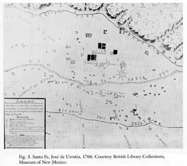
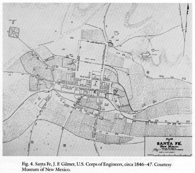
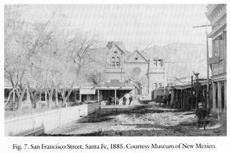
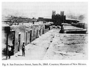
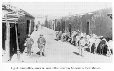
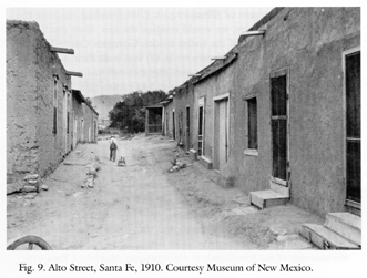
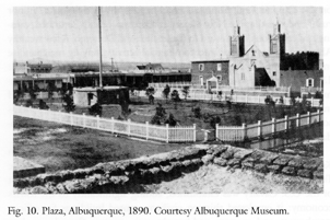
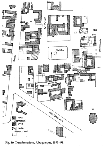
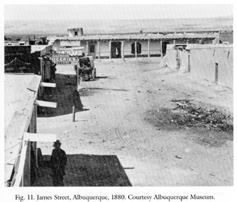
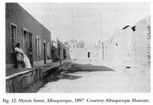
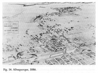
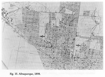
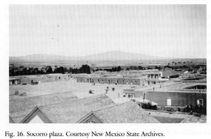
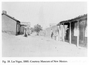
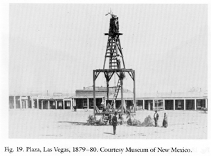
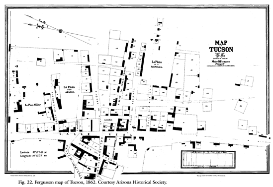
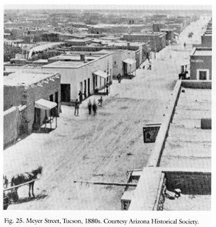
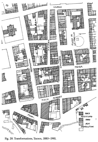
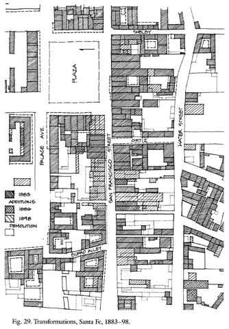